 Filter: Categories of Wisconsin Historical Images
Filter: Subject of Forests and forestry
Filter: Year of 1900-1999
Filter: Year of 1930-1939
Filter: Categories of Wisconsin Historical Images
Filter: Subject of Forests and forestry
Filter: Year of 1900-1999
Filter: Year of 1930-1939
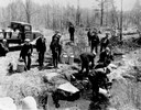
| Date: | 04 26 1936 |
|---|---|
| Description: | Planting trout in Waupaca County. Left to right on bank: S.A. LaVoilette, Joe Samz, Lloyd Pinkawski, Edwin Kargewski, W.M. Geiger, G. Moder, Billy LaVoilet... |
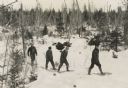
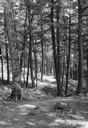
| Date: | 1935 |
|---|---|
| Description: | Winter scene with four men walking on snowshoes through a forest. |
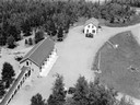
| Date: | 07 1936 |
|---|---|
| Description: | Elevated view of the Mercer Ranger Station from a watchtower. |
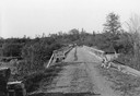
| Date: | 06 01 1936 |
|---|---|
| Description: | Bridge and truck trail constructed by Works Progress Administration (WPA) workmen to facilitate forest fire prevention and control. |
| Date: | 07 1936 |
|---|---|
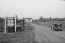
| Description: | Checking station at the entrance of Chequamegon National Forest in Taylor County. |
| Date: | 08 1936 |
|---|---|
| Description: | Trail through Copper Falls State Park along the west bluff, through virgin hemlock timber. |
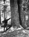
| Date: | 01 01 1934 |
|---|---|
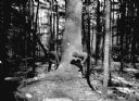
| Description: | Man in uniform leaning up against the base of a large tree. |
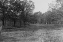
| Date: | 1930 |
|---|---|
| Description: | View of a wide path through trees in the spring or summer. |

| Date: | 1930 |
|---|---|
| Description: | Aerial view of Hoyt Park including the surrounding neighborhoods. Resurrection Cemetery can be seen at the upper right of the image. |

| Date: | 1930 |
|---|---|
| Description: | Aerial view of the University of Wisconsin-Madison Arboretum including a portion of Lake Wingra and surrounding residential neighborhoods. |

| Date: | 1930 |
|---|---|
| Description: | Aerial view of the University of Wisconsin-Madison Arboretum including the surrounding residential neighborhoods. |
| Date: | 1931 |
|---|---|
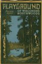
| Description: | Cover of a Wisconsin tourism pamphlet for the 1932 season. |

| Date: | 1930 |
|---|---|
| Description: | A view looking west at Rib Mountain across the Wisconsin River from the outskirts of Wausau. |

| Date: | 1939 |
|---|---|
| Description: | A color, pictorial map. Scale: 10 miles to the inch. Shows state parks and forests, proposed state parkways, proposed state monuments and memorials, nation... |

| Date: | 03 1939 |
|---|---|
| Description: | A man mapping a planted stand of white pines in Devil's Lake State Park. He is wearing snowshoes. |

| Date: | 1936 |
|---|---|
| Description: | Loading a large white pine log cut on the Menominee Indian Reservation onto a truck. The log was hauled to the Wisconsin State Fair for a display about the... |
| Date: | 03 1938 |
|---|---|
| Description: | A large white pine being felled on the Menominee Indian Reservation. This photograph was taken to illustrate the tribe's selective logging practices. |
| Date: | 1935 |
|---|---|
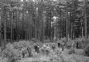
| Description: | Slightly elevated view of a ribes eradication crew that was part of the white pine blister rust effort in a Barron County forest. The caption indicates tha... |
| Date: | 1935 |
|---|---|
| Description: | Barracks buildings at the Crystal Lake Civilian Conservation Corps (CCC) camp. |
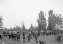
| Date: | 1938 |
|---|---|
| Description: | A crew of Civilian Conservation Corps (CCC) youth starting for the field where they were working on ribes eradication as part of the effort to defeat the w... |
If you didn't find the material you searched for, our Library Reference Staff can help.
Call our reference desk at 608-264-6535 or email us at: