 Filter: Categories of Wisconsin Historical Images
Filter: Subject of Fortification
Filter: Creator Name of Unknown
Filter: Community of Green Bay
Filter: Year of 1900-1999
Filter: Categories of Wisconsin Historical Images
Filter: Subject of Fortification
Filter: Creator Name of Unknown
Filter: Community of Green Bay
Filter: Year of 1900-1999
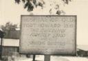
| Date: | 1925 |
|---|---|
| Description: | Fort Howard Hospital Marker. "Hospital of old Fort Howard - 1816. This building formerly stood with the surgeons quarters and the powder magazine on the ri... |
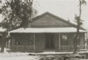
| Date: | 1938 |
|---|---|
| Description: | Annex of Old Fort Howard. Caption reads: "Annex of Old Fort Howard, Green Bay, Wis." |
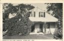
| Date: | 1925 |
|---|---|
| Description: | View of the front of the annex, prior to restoration. |

| Date: | 1914 |
|---|---|
| Description: | This map is a photostat copy from the original 1829 map in the War Department. The map shows location of Fort Howard, lots, land claims of Jacques Porlier ... |

| Date: | 1930 |
|---|---|
| Description: | This map shows a plat of the town, local streets, railroads, creeks, part of Fox River, and part of the bay of Green Bay. The location of the original fort... |

| Date: | 1900 |
|---|---|
| Description: | This photocopied map shows private claim owners, buildings, and land use in 1818. Insets show Fort Howard and the caption reads: "A view of the Fox River ... |
If you didn't find the material you searched for, our Library Reference Staff can help.
Call our reference desk at 608-264-6535 or email us at: