 Filter: Categories of Wisconsin Historical Images
Filter: Subject of Fortification
Filter: Creator Name of Unknown
Filter: County of Columbia
Filter: Subject of cities and towns
Filter: Categories of Wisconsin Historical Images
Filter: Subject of Fortification
Filter: Creator Name of Unknown
Filter: County of Columbia
Filter: Subject of cities and towns
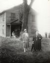
| Date: | 07 07 1929 |
|---|---|
| Description: | Miss Mary Prescott and Mrs. William McMahon, grandaughter and great grandaughter, respectively, of Pierre Paquette, appeared at a meeting called by the Wis... |

| Date: | 1855 |
|---|---|
| Description: | Fox-Wisconsin portage and canal map, when the canal was not yet built. From a map in the office of the city clerk at Portage. "The old trail, the location ... |

| Date: | 1800 |
|---|---|
| Description: | This map shows the land claim owned by the Portage Canal Company and includes an index of landownership and landmarks. The Wisconsin and Portage River, the... |

| Date: | 1914 |
|---|---|
| Description: | This photostat map shows Fort Winnebago around 1931, land to be reserved for military purposes, roads to Fort Howard and Fort Crawford, "private property" ... |

| Date: | 1900 |
|---|---|
| Description: | This manuscript map shows outline of Fort Winnebago reserve land, Fort Winnebago, claim of A. Grignon, and Indian boundaries. The Fox River and Swan Lake a... |
If you didn't find the material you searched for, our Library Reference Staff can help.
Call our reference desk at 608-264-6535 or email us at: