Filter: Categories of Wisconsin Historical Images
Filter: Subject of Fortification
Filter: Creator Name of Unknown
Filter: County of Crawford
Filter: Subject of human settlements
Filter: Categories of Wisconsin Historical Images
Filter: Subject of Fortification
Filter: Creator Name of Unknown
Filter: County of Crawford
Filter: Subject of human settlements

| Date: | 1840 |
|---|---|
| Description: | Fort Crawford (the second site, with buildings of 1829-?), on the east bank of the Mississippi River, about 2 miles above the mouth of the Wisconsin River. |
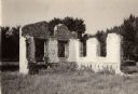
| Date: | 1910 |
|---|---|
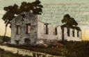
| Description: | Fort Crawford. Caption reads: "Ruins of hospital, old Fort Crawford, Prairie du Chien, Wis." |
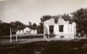
| Date: | 1900 |
|---|---|
| Description: | A view of the ruins of the guardhouse used in 1883. Caption reads: "Ruins of Fort Crawford, Prairie du Chien, Wis." |

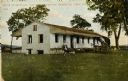
| Date: | 1910 |
|---|---|
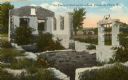
| Description: | Fort Crawford ruins. Caption reads: "Ruins of Old Fort Crawford, Prairie-du-Chien, Wis." |
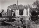
| Date: | 1925 |
|---|---|
| Description: | Fort Crawford (the second site, showing ruins of the building of 1892-?). These are the ruins of the hospital. Caption reads: "The Ruins of Old Fort Crawfo... |

| Date: | 1840 |
|---|---|
| Description: | A view of Fort Crawford (the second site and buildings of 1829-?). |

| Date: | 1882 |
|---|---|
| Description: | This map is ink on cardboard and shows the location of military forts over the course of years. Also shown are points of interest, streets, the Mississippi... |

| Date: | 1828 |
|---|---|
| Description: | This plat map is pen-and-ink and shows landowners, the Mississippi River, the Marais de St. Friole, Fort Crawford, the town commons, and the Village of St.... |

| Date: | |
|---|---|
| Description: | This map is pen-and-ink on tracing paper with a mounted legend and shows the Kickapoo River, Indian mounds, the 1st Fort Crawford, an Indian Agency, the si... |

| Date: | 1900 |
|---|---|
| Description: | This photocopy map shows proposed buildings and building use at Fort Crawford. |

| Date: | 1900 |
|---|---|
| Description: | This photocopy map shows marshes, woods, buildings, and selected features including islands, mounds, old Fort Crawford, and "new site for a fort in questio... |
| Date: | |
|---|---|
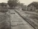
| Description: | Completed excavations at Fort Crawford showing the north row of buildings. Caption reads: "N. Row Bldgs. Completed excavations, Ft. Crawford." |
If you didn't find the material you searched for, our Library Reference Staff can help.
Call our reference desk at 608-264-6535 or email us at: