 Filter: Categories of Wisconsin Historical Images
Filter: Subject of Fortification
Filter: Creator Name of Unknown
Filter: Year of 1800-1899
Filter: Subject of water
Filter: Categories of Wisconsin Historical Images
Filter: Subject of Fortification
Filter: Creator Name of Unknown
Filter: Year of 1800-1899
Filter: Subject of water

| Date: | 1851 |
|---|---|
| Description: | A rare photograph of U.S. Army soldiers stationed at Fort Howard rowing a boat on the Fox River. Fort Howard, built in 1816, was the first in the chain of ... |
| Date: | 1860 |
|---|---|
| Description: | Nine men arrive at Fort William by canoe. Fort William, also called Kaministiguia, was the Hudson's Bay fur trading post. Men are standing along the opposi... |

| Date: | 1831 |
|---|---|
| Description: | Drawing of Fort Winnebago (near present-day Portage) that illustrated "Wau-Bun," Juliette Kinzie's memoir of her experiences on the early Wisconsin fronti... |

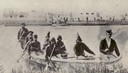
| Date: | 1851 |
|---|---|
| Description: | View of five soldiers rowing in a boat, beside a dock, with another soldier standing on the dock. The fort is in the background, complete with the fortifie... |

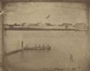
| Date: | 1851 |
|---|---|
| Description: | Several men rowing in a boat near Fort Howard that has an American Flag, barracks, and various related military buildings enclosed behind a wall. |

| Date: | 1814 |
|---|---|
| Description: | Fort Shelby, built by the Americans during the War of 1812. In 1814 the fort surrendered to British forces led by Captain Andrew W. Bulger who renamed it F... |

| Date: | 1840 |
|---|---|
| Description: | Fort Crawford (the second site, with buildings of 1829-?), on the east bank of the Mississippi River, about 2 miles above the mouth of the Wisconsin River. |

| Date: | 1840 |
|---|---|
| Description: | A view of Fort Crawford (the second site and buildings of 1829-?). |

| Date: | 1855 |
|---|---|
| Description: | Fox-Wisconsin portage and canal map, when the canal was not yet built. From a map in the office of the city clerk at Portage. "The old trail, the location ... |
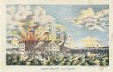
| Date: | 1861 |
|---|---|
| Description: | Color lithograph of the fort in the midst of the bombardment, published by Bingham & Dodd, Hartford, Connecticut. |

| Date: | 1880 |
|---|---|
| Description: | A scene from a panoramic painting of Grant's assault on Vicksburg. |

| Date: | 1882 |
|---|---|
| Description: | This map is ink on cardboard and shows the location of military forts over the course of years. Also shown are points of interest, streets, the Mississippi... |

| Date: | 1800 |
|---|---|
| Description: | This map shows the land claim owned by the Portage Canal Company and includes an index of landownership and landmarks. The Wisconsin and Portage River, the... |

| Date: | 1800 |
|---|---|
| Description: | This map is pencil on tracing paper and shows marshes, the Wisconsin River, Indian trails, and Indian boundary line. The upper left corner reads: "Let sect... |

| Date: | 1828 |
|---|---|
| Description: | This plat map is pen-and-ink and shows landowners, the Mississippi River, the Marais de St. Friole, Fort Crawford, the town commons, and the Village of St.... |

| Date: | 1814 |
|---|---|
| Description: | A map of the Harbour (sic) of St. Catherine (Brazil). |
| Date: | 1851 |
|---|---|
| Description: | A rare photograph of U.S. Army soldiers stationed at Fort Howard rowing a boat on the Fox River. Fort Howard, built in 1816, was the first in the chain of ... |

| Date: | 1818 |
|---|---|
| Description: | Overhead view of the layout of the fort, with the Fox River at the top, and a "Cranberry Marsh of 1/2 mile in extent" below right. At the bottom is a rende... |
If you didn't find the material you searched for, our Library Reference Staff can help.
Call our reference desk at 608-264-6535 or email us at: