 Filter: Categories of Wisconsin Historical Images
Filter: Subject of Fortification
Filter: Creator Name of Unknown
Filter: Categories of Wisconsin Historical Images
Filter: Subject of Fortification
Filter: Creator Name of Unknown
| Date: | |
|---|---|
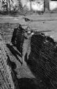
| Description: | A man demonstrating trench shooting in a fortified ditch at Camp Lewis, built in 1917. |
| Date: | |
|---|---|
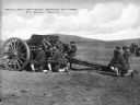
| Description: | A view of soldiers in an open field during artillery practice at The School of Fire, founded in 1911 at Fort Sill. Caption reads: "Artillery Practice, Scho... |
| Date: | |
|---|---|
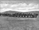
| Description: | A view of horse-drawn artillery at the School of Fire, established in 1911 at Fort Sill. Caption reads: "Artillery Practice, School of Fire, Ft. Sill, OKLA... |

| Date: | 1918 |
|---|---|
| Description: | Men observe an early airplane at Camp Bowie, established in 1917. |
| Date: | |
|---|---|
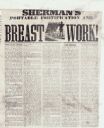
| Description: | An article discussing a new device to protect Union infantry from the enemy while they are advancing. |
| Date: | 1860 |
|---|---|
| Description: | Scene of 16 figures. A slave owner is raising his whip as black families are racing towards Fort Monroe, with some remaining behind picking cotton. The sla... |

| Date: | |
|---|---|
| Description: | A hand-drawn map including the location of Daniel Boone's home and two forts, northeast of Lexington, Kentucky. |
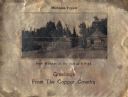
| Date: | 1930 |
|---|---|
| Description: | Holiday card printed on a sheet of copper. It has a scene of log buildings, a stockade fence, and woods in the background. Above is the text "Michigan Copp... |
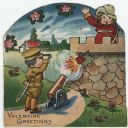
| Date: | |
|---|---|
| Description: | Valentine's Day card featuring a girl wearing a red uniform and a sword, standing on the roof of a fort. A boy in a tan uniform with a sword, is looking at... |

| Date: | |
|---|---|
| Description: | Men work outside dwellings along a shoreline in a reproduction of a painting by W.L. Williams. Copyright by A.S. Burbank, 1891. |
| Date: | 1853 |
|---|---|
| Description: | Stereograph of the interior of Fort Howard after its decommissioning in 1853. |

| Date: | 1914 |
|---|---|
| Description: | This map is a photostat copy from the original 1829 map in the War Department. The map shows location of Fort Howard, lots, land claims of Jacques Porlier ... |
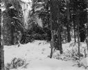
| Date: | 1918 |
|---|---|
| Description: | View across snow towards a camouflaged log blockhouse constructed during the Allied Intervention in Northern Russia. The fortification is surrounded by a f... |
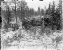
| Date: | 1918 |
|---|---|
| Description: | View through trees and branches of a log blockhouse fortification used by the Allied forces. The fortification is in a heavily forested area and camouflage... |
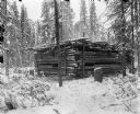
| Date: | 1918 |
|---|---|
| Description: | A log blockhouse under construction to support the Allied Intervention in Northern Russia. The fortification is surrounded by a forested area covered in sn... |
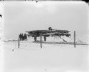
| Date: | 1918 |
|---|---|
| Description: | View across snow and barbed wire fence of a group of soldiers constructing a log blockhouse. |
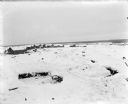
| Date: | 1918 |
|---|---|
| Description: | Trenches constructed for American forces to defend against the Bolshevik "Red" forces. In the background are possibly barracks and other buildings for the ... |
| Date: | 1918 |
|---|---|
| Description: | A group of possibly both American and British soldiers standing just outside a blockhouse fortification. There are piles of logs and an axe on the ground i... |
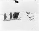
| Date: | 1918 |
|---|---|
| Description: | View across snow of two soldiers standing outside a blockhouse fortification. One soldier is wearing heavy wool furs and is armed with a rifle, and the oth... |
If you didn't find the material you searched for, our Library Reference Staff can help.
Call our reference desk at 608-264-6535 or email us at:
