 Filter: Categories of Wisconsin Historical Images
Filter: Subject of Fortification
Filter: Creator Name of Unknown
Filter: Year of 1700-1799
Filter: Categories of Wisconsin Historical Images
Filter: Subject of Fortification
Filter: Creator Name of Unknown
Filter: Year of 1700-1799
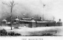
| Date: | 1790 |
|---|---|
| Description: | Fort Washington, built in 1789, where Cincinnati now stands. |

| Date: | 1755 |
|---|---|
| Description: | Map of New England, with three inset maps of Fort Oswego, Fort du Quesne, and Fort Frederick. It shows colonies, a few cities, forts (marked as French or E... |

| Date: | 1776 |
|---|---|
| Description: | Fairly detailed map of New York City and parts of Long Island. It shows streets, roads, wharves, ferries, ship yards, Fort George and the battery, public b... |
If you didn't find the material you searched for, our Library Reference Staff can help.
Call our reference desk at 608-264-6535 or email us at: