Filter: Categories of Wisconsin Historical Images
Filter: Subject of Fortification
Filter: County of Crawford
Filter: Categories of Wisconsin Historical Images
Filter: Subject of Fortification
Filter: County of Crawford

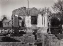
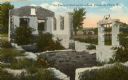
| Date: | 1910 |
|---|---|
| Description: | Fort Crawford ruins. Caption reads: "Ruins of Old Fort Crawford, Prairie-du-Chien, Wis." |

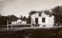
| Date: | 1915 |
|---|---|
| Description: | Ruins of Fort Crawford. A windmill is in the background on the right. Caption reads: "Ruins of Fort Crawford, Prairie du Chien, Wis." |
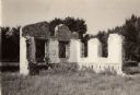
| Date: | 1925 |
|---|---|
| Description: | Fort Crawford (the second site, showing ruins of the building of 1892-?). These are the ruins of the hospital. Caption reads: "The Ruins of Old Fort Crawfo... |

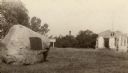
| Date: | 1875 |
|---|---|
| Description: | Fort Crawford ruins. This image may be even earlier than 1875; by the 1880's almost nothing was left of the actual fort compound buildings. Men are sitting... |

| Date: | 1840 |
|---|---|
| Description: | A view of Fort Crawford (the second site and buildings of 1829-?). |

| Date: | 1823 |
|---|---|
| Description: | British evacuation of their fort at Prairie du Chien after the end of the War of 1812. Fort Shelby, the first fort at Prairie du Chien, was built in 1814 b... |

| Date: | 1829 |
|---|---|
| Description: | Fort Crawford, from a sketchbook attributed to Seth Eastman, 1808-1875. A graduate of West Point, Eastman briefly served at Fort Crawford, 1829-1839. |
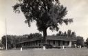
| Date: | 08 1931 |
|---|---|
| Description: | The Beaumont memorial marker on the site of Fort Crawford. |

| Date: | 1820 |
|---|---|
| Description: | This map displays the plan for claiming various settlement zones in the Prairie des Chiens area in 1820. It shows Fort Crawford and 87 confirmed and unconf... |

| Date: | 1882 |
|---|---|
| Description: | This map is ink on cardboard and shows the location of military forts over the course of years. Also shown are points of interest, streets, the Mississippi... |

| Date: | 01 15 1929 |
|---|---|
| Description: | Intended for tourists, this brochure, titled: "Winneshiek World’s Famous Wild Life Refuge Historic Fort Crawford and Picturesque Prairie du Chien," feature... |

| Date: | 1950 |
|---|---|
| Description: | Intended for tourists, this brochure features two maps with tourists sites along the Mississippi River. One map shows roads and populated places along the ... |

| Date: | 1856 |
|---|---|
| Description: | This map shows lot and block numbers, streets, the Mississippi River, Fort Crawford, depot ground, and a graveyard. An old fort location is outlined in red... |

| Date: | 12 05 1854 |
|---|---|
| Description: | This plat map shows landowners, the Mississippi River, the Marais de St. Friole, and an old fort. The left margin reads: "Part of the Main Village of Prair... |

| Date: | 1828 |
|---|---|
| Description: | This plat map is pen-and-ink and shows landowners, the Mississippi River, the Marais de St. Friole, Fort Crawford, the town commons, and the Village of St.... |
If you didn't find the material you searched for, our Library Reference Staff can help.
Call our reference desk at 608-264-6535 or email us at: