 Filter: Categories of Wisconsin Historical Images
Filter: Subject of Fortification
Filter: Year of 1800-1899
Filter: Year of 1860-1869
Filter: Year of 1862
Filter: Categories of Wisconsin Historical Images
Filter: Subject of Fortification
Filter: Year of 1800-1899
Filter: Year of 1860-1869
Filter: Year of 1862
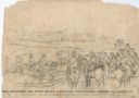
| Date: | 10 03 1862 |
|---|---|
| Description: | "General Rosecranz and staff huredly [sic] erecting earthworks during the Battle at Corinth. The enemy driving in our lines." Men are on horses on a... |
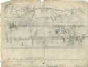
| Date: | 10 03 1862 |
|---|---|
| Description: | "Combined Confederate attack upon [Batteries] Robinette and Davis the attack on Battery Robinette being defeated and that on Davis resulting in the defeat ... |
| Date: | 04 1862 |
|---|---|
| Description: | Notes include: Sketch of Battle of Island #10. Sketch of Fort Pillow Tennessee. Gen. Pope had command of the land troops. |
| Date: | 02 15 1862 |
|---|---|
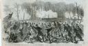
| Description: | "The 2nd and 7th Iowa and the 52nd Indiana headed by General Smith storming up the rebel works at Fort Donelson causing its surrender to General Grant the ... |
| Date: | 1862 |
|---|---|
| Description: | Fort Lincoln, Kansas, when the 12th Wisconsin Volunteers arrived on their march from Fort Scott to Lawrence. A watercolor by John Gaddis of Company E. |
| Date: | 04 1862 |
|---|---|
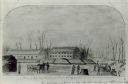
| Description: | Stationery depicting the fortifications around Washington, D.C., during the second year of the Civil War: Arlington Heights, directly across the Potomac Ri... |
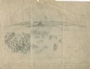
| Date: | 1862 |
|---|---|
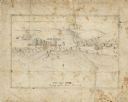
| Description: | A small amateur drawing of the camp, with surrounding terrain, occupied by the 104th Regiment, New York State Volunteers near Belle Plains, Virginia, durin... |
| Date: | 03 15 1862 |
|---|---|
| Description: | Engraved Illustration for the story titled: "The Fight at Fort Donelson". The illustration shows the Second Iowa Volunteers regiment attacking Confederate ... |

| Date: | 1862 |
|---|---|
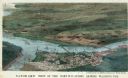
| Description: | This map lists and depicts the positions of "the batteries on Kentucky shore" and the "batteries on Island No. 10." The 8th Wisconsin Infantry and 15th Wis... |
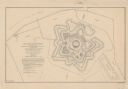
| Date: | 1862 |
|---|---|
| Description: | This detailed plan of Fort Jackson, in Plaquemines Parish, Louisiana, indicates the damage inflicted by the April, 1862, bombardment of the fort by Union f... |

| Date: | 1862 |
|---|---|
| Description: | Map of southeastern Virginia indicating fortifications, towns, roads, railroads, drainage, and some vegetation. 2 sheets, each mounted on 1 sheet. |

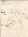
| Date: | 1862 |
|---|---|
| Description: | This map shows landownership on a military reserve, private claims, buildings (including Fort Howard and U.S. sawmill), swamps, public barns and fields, an... |
If you didn't find the material you searched for, our Library Reference Staff can help.
Call our reference desk at 608-264-6535 or email us at: