 Filter: Categories of Wisconsin Historical Images
Filter: Subject of Fortification
Filter: Year of 1900-1999
Filter: Year of 1900-1909
Filter: Categories of Wisconsin Historical Images
Filter: Subject of Fortification
Filter: Year of 1900-1999
Filter: Year of 1900-1909
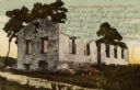
| Date: | 1900 |
|---|---|
| Description: | A view of the ruins of the guardhouse used in 1883. Caption reads: "Ruins of Fort Crawford, Prairie du Chien, Wis." |

| Date: | 1905 |
|---|---|
| Description: | Front view of the Block House, built in 1880, at the Pennsylvania Soldiers' and Sailors' Home. The United States flag waves on a pole atop the Block House.... |

| Date: | 1900 |
|---|---|
| Description: | This map of Green Bay shows plat of the town, lots by number, local streets, the military Fort Howard, part of Fox River and part of Navarino. The map feat... |

| Date: | 1900 |
|---|---|
| Description: | This map of West Navarino shows plat of the town, lots by number, local streets, public square, The Fox River, and Fort Howard. The bottom of the map reads... |

| Date: | 1900 |
|---|---|
| Description: | This photostat of a manuscript map originally drawn in 1829 shows landownership, buildings, including Fort Howard and U.S. sawmill, swamps, public barns an... |

| Date: | 1900 |
|---|---|
| Description: | This photostat map shows private claim owners, natural meadows, roads, saw and grist mills, and Fort Howard. The upper right corner includes annotations an... |

| Date: | 1900 |
|---|---|
| Description: | This photocopied map shows private claim owners, buildings, and land use in 1818. Insets show Fort Howard and the caption reads: "A view of the Fox River ... |

| Date: | 1900 |
|---|---|
| Description: | This map shows a proposed route of for a road linking military forts. The map also includes communities, lakes, and rivers. The map is accompanied by a rep... |

| Date: | 1900 |
|---|---|
| Description: | This map shows the boundary lines between ceded and unceded land in compliance with the Treaty of Prairie du Chen of 1829. It also shows roads, rivers, por... |

| Date: | 1900 |
|---|---|
| Description: | This map shows portion of the military road from Fond du Lac to the Wisconsin River near Fort Winnebago, with mile markers and adjacent land use. A few pro... |

| Date: | 1900 |
|---|---|
| Description: | This photocopy map shows proposed buildings and building use at Fort Crawford. |

| Date: | 1900 |
|---|---|
| Description: | This manuscript map shows outline of Fort Winnebago reserve land, Fort Winnebago, claim of A. Grignon, and Indian boundaries. The Fox River and Swan Lake a... |

| Date: | 1900 |
|---|---|
| Description: | This photocopy map shows marshes, woods, buildings, and selected features including islands, mounds, old Fort Crawford, and "new site for a fort in questio... |
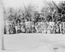
| Date: | 1900 |
|---|---|
| Description: | A group of men posing together in front of a stand of trees. Caption reads: "Indian 'Sun Dance' near Fort Washakie, Wyo, 1900." |

| Date: | 1907 |
|---|---|
| Description: | View of a post tower at Fort Snelling. A tree partially obscures the tower. Flags are arrayed on the battlements and the number "1820" (the year fort const... |
If you didn't find the material you searched for, our Library Reference Staff can help.
Call our reference desk at 608-264-6535 or email us at:
