 Filter: Categories of Wisconsin Historical Images
Filter: Subject of Geology
Filter: Categories of Wisconsin Historical Images
Filter: Subject of Geology
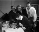
| Date: | 03 26 1957 |
|---|---|
| Description: | George Hanson (seated foreground center), state geologist, peers into a microscope while examining a diamond. Leaning in to look on are (left to right) Pro... |

| Date: | |
|---|---|
| Description: | A hand-colored geological cross section of Iowa County and eastern Dane County, Wisconsin, from the Blue Mounds north-northwest to the sandy plain of the W... |

| Date: | 1836 |
|---|---|
| Description: | A detailed map of the mouth of the Kewaunee River, showing the geological composition of the Lake Michigan shoreline and the various water depths in the ar... |
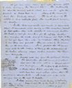
| Date: | 1870 |
|---|---|
| Description: | Page from a diary kept by Increase Lapham in California between April 11 and May 19, 1870. The page shows a portion of a list of minerals of California. |
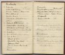
| Date: | 06 28 1850 |
|---|---|
| Description: | Letter from Increase Lapham to his wife, Ann Maria Alcott, in Milwaukee. Lapham was at Aztalan and wrote to Anna regarding the geology of the region. He in... |

| Date: | 1828 |
|---|---|
| Description: | Drawing by Increase Lapham showing the geological profile of the land between Utica and Knob Creek, Kentucky at a scale of 1/2 inch to a mile. |

| Date: | 12 22 1830 |
|---|---|
| Description: | Increase Lapham's drawing of the geological profile between the Sandusky plains and Portsmouth, Ohio. |
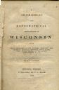
| Date: | 1844 |
|---|---|
| Description: | Title page of Increase Lapham's A Geographical and Topographical Description of Wisconsin published by P.C. Hale of Milwaukee, Wisconsin. |

| Date: | 1828 |
|---|---|
| Description: | Increase Lapham's drawing and description of an earth borer for his handwritten manuscript, Notes and Accounts of Canals, Particularly the Ohio Canal Ne... |

| Date: | 1902 |
|---|---|
| Description: | This map is watercolor and pen on paper and relief shown by contours. The map reads: "Contour interval 10 feet." Shown on the map are geological features a... |
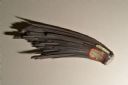
| Date: | 11 12 2013 |
|---|---|
| Description: | A hematite fan, approximately six inches in length, from the mineral collection of Ferdinand Hotz at the University of Wisconsin Geology Museum. This speci... |
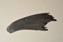
| Date: | 11 12 2013 |
|---|---|
| Description: | A hematite fan, approximately six inches in length, from the mineral collection of Ferdinand Hotz at the University of Wisconsin Geology Museum. This speci... |
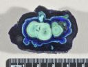
| Date: | 11 12 2013 |
|---|---|
| Description: | A cut and polished azurite malachite nodule from the mineral collection of Ferdinand Hotz at the University of Wisconsin Geology Museum. Azurite and malach... |
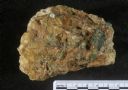
| Date: | 11 12 2013 |
|---|---|
| Description: | A specimen of emerald in matrix from the mineral collection of Ferdinand Hotz at the University of Wisconsin Geology Museum. |
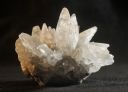
| Date: | 11 12 2013 |
|---|---|
| Description: | A dogtooth calcite specimen from the mineral collection of Ferdinand Hotz at the University of Wisconsin Geology Museum. The specimen is approximately thre... |

| Date: | 1883 |
|---|---|
| Description: | This map shows the geology of areas in Montana, the Dakotas, Nebraska, Wyoming, Idaho, Colorado, Kansas, Arizona, New Mexico, and Utah. Map also shows lake... |

| Date: | 03 1965 |
|---|---|
| Description: | Keith Brigham is shown checking the U.S. Geological Survey stream gauging station located at the Yahara river locks on Lake Waubesa near McFarland. |

| Date: | 1862 |
|---|---|
| Description: | This map shows the population by county, the basic geology, climate, and the distribution of timber within the state of Wisconsin. It shows mean seasonal t... |

| Date: | 1892 |
|---|---|
| Description: | This map shows rivers, lakes, railroad lines, roads, and communities in addition to geological data. The map includes cross-sections in the bottom margin a... |

| Date: | 1864 |
|---|---|
| Description: | This map is pen and watercolor on paper and shows a profile and geological sections of the Blue Mounds, Hollow Run, Bogies Hollow Run, Bear Creek, East Bre... |
If you didn't find the material you searched for, our Library Reference Staff can help.
Call our reference desk at 608-264-6535 or email us at: