 Filter: Categories of Wisconsin Historical Images
Filter: Subject of Great Lakes
Filter: Creator Name of Chapman, Silas
Filter: Categories of Wisconsin Historical Images
Filter: Subject of Great Lakes
Filter: Creator Name of Chapman, Silas
| Date: | 1859 |
|---|---|
| Description: | 1859 sectional map of the state of Wisconsin. |

| Date: | 1858 |
|---|---|
| Description: | Drawn a decade after Wisconsin entered statehood, this 1858 map depicts counties, creeks, rivers, lakes, railroads completed, railroads in progress and com... |

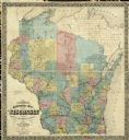
| Date: | 1855 |
|---|---|
| Description: | This map depicts counties, creeks, rivers, lakes, railroads completed, railroads in progress, common roads and the Menomonee Reservation. |
If you didn't find the material you searched for, our Library Reference Staff can help.
Call our reference desk at 608-264-6535 or email us at: