 Filter: Categories of Wisconsin Historical Images
Filter: Subject of Guard fences
Filter: Subject of outdoor photography
Filter: Creator Name of Unknown
Filter: Categories of Wisconsin Historical Images
Filter: Subject of Guard fences
Filter: Subject of outdoor photography
Filter: Creator Name of Unknown
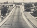
| Date: | 1935 |
|---|---|
| Description: | Elevated view of the bridge, with several cars driving on it. On the left and right are streets below the bridge. In the distance are smokestacks and water... |
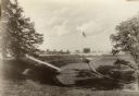
| Date: | 1935 |
|---|---|
| Description: | View of Kohler Ravine Park. In the right foreground is a small bridge, and on the right is a set of wide, concrete steps leading from the road down the hil... |
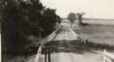
| Date: | 1918 |
|---|---|
| Description: | Amery Road near New Richmond. The photograph was taken by the Wisconsin Good Roads Association probably as an illustration of the kind of improved roads t... |

| Date: | |
|---|---|
| Description: | A dirt road along the shore, featuring a log guardrail and a boathouse in the distance. Caption reads: "The Shore Road, Lloyd's Neck, Huntington, N.Y." |
| Date: | |
|---|---|
| Description: | A view of a car on a dirt road driving toward Mt. Tom Camp, with a wooden guardrail on one side and a natural rock formation on the other side. |
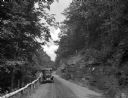
| Date: | |
|---|---|
| Description: | A view of a car driving on a dirt road along the Naugatuck River, with a wooden guardrail and river on one side, and a rock formation on the other. |

| Date: | |
|---|---|
| Description: | A view of a country dirt road with a car pulled over to the right side. The road is part of the Pennsylvania State Highway, and is bordered by a fence on o... |
| Date: | |
|---|---|
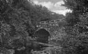
| Description: | View along quiet stream lined with trees and foliage toward an arched stone bridge with a guardrail. |

| Date: | |
|---|---|
| Description: | Elevated view of the Lincoln Highway, also known as the Juniata Bridge, or Juniata Crossing. View toward right side of bridge over a river, with tree-cover... |
| Date: | |
|---|---|
| Description: | Black and white postcard of an elevated view of the Old Covered Bridge crossing the Wisconsin River. The bridge is on the left and the river is on the righ... |

| Date: | |
|---|---|
| Description: | Rear view of a bed box built by the Ideal Body Company for the Wisconsin Power and Light Company. A man is standing on the right of the truck, which is par... |

| Date: | 1932 |
|---|---|
| Description: | Looking west along County Trunk Highway SS (now CTH DD) from the hill east of the New Fane School. The brick school, with its bell tower and widow's walk, ... |

| Date: | |
|---|---|
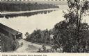
| Description: | Photographic postcard view of a covered bridge over the Wisconsin River. Men are fishing at the base of a pylon, and other men are boating in the river. Th... |

| Date: | |
|---|---|
| Description: | Photographic postcard view downhill towards an intersection in the north woods. Three cars are driving away up the hill on the other side of the intersecti... |

| Date: | |
|---|---|
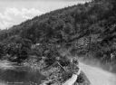
| Description: | View across unpaved rural road that curves around to the left around a large rock formation with an exposed rock face with trees growing on the top. There ... |

| Date: | |
|---|---|
| Description: | View of Friendship Mound — a rocky outcropping, from the road below. |
| Date: | |
|---|---|
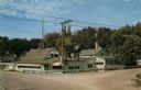
| Description: | Color postcard view from intersection towards a roadside tavern. Text on reverse reads: "TIBBIES Where Chicken is King at Indian Ford, Wis. Three miles... |

| Date: | |
|---|---|
| Description: | Photographic postcard view of a two-lane Interstate highway along railroad tracks. Two automobiles are moving down the road in the right lane, heading towa... |

| Date: | 1935 |
|---|---|
| Description: | Three men are standing and posing with Minnesota highway signs near a post and cable guard rail. US 61 and US 14 are on two signs. They men are wearing mot... |
| Date: | |
|---|---|
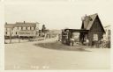
| Description: | Photographic postcard view of the road through a small settlement. A dwelling and a service station are on the right. A general store on the left is on the... |
If you didn't find the material you searched for, our Library Reference Staff can help.
Call our reference desk at 608-264-6535 or email us at: