 Filter: Categories of Wisconsin Historical Images
Filter: Subject of Historic sites
Filter: Type of Map or Atlas
Filter: Categories of Wisconsin Historical Images
Filter: Subject of Historic sites
Filter: Type of Map or Atlas

| Date: | 1939 |
|---|---|
| Description: | A color, pictorial map. Scale: 10 miles to the inch. Shows state parks and forests, proposed state parkways, proposed state monuments and memorials, nation... |
| Date: | 1931 |
|---|---|
| Description: | This map "sets out the more important points of historic interest designated by the National Society of Colonial Dames in Wisconsin" and includes illustrat... |

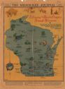
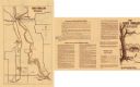
| Date: | 1941 |
|---|---|
| Description: | This pictorial map of Wisconsin with historical text highlights the history of the state and identifies places of interest, Indian villages, missions, trad... |

| Date: | 1990 |
|---|---|
| Description: | A tourist map of Lafayette County, Wisconsin, that shows the locations of motels, camping, municipal parks, cheese factory tours, waysides, and golf course... |

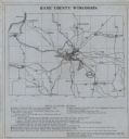
| Date: | 1961 |
|---|---|
| Description: | This 1961 map of Ozaukee County, Wisconsin, identifies historic sites and landmarks in the county. Cities and villages, roads, and lakes and streams are al... |
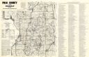
| Date: | 1980 |
|---|---|
| Description: | This road map of Polk County, Wisconsin, has been annotated to show the location of historic sites in the county and is accompanied by a 1980 directory of ... |
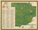
| Date: | |
|---|---|
| Description: | This map shows the locations of historic sites and points of interest in Rusk County, Wisconsin. A location key, descriptions of the historical importance ... |
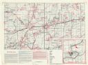
| Date: | 1975 |
|---|---|
| Description: | This 1975 map of Sauk County, Wisconsin, lists and locates historic sites and other points of interest in the county. |

| Date: | 1976 |
|---|---|
| Description: | This 1976 map of Washington County, Wisconsin, shows towns, cities and villages, highways and roads, existing and proposed county trails, and various publi... |

| Date: | 1960 |
|---|---|
| Description: | This mid-20th century tourist brochure for Bayfield County, Wisconsin, includes a map of the county showing towns, cities and villages, highways and roads,... |

| Date: | 1975 |
|---|---|
| Description: | This 1975 road map of Columbia County, Wisconsin, shows the location of historic sites in the county but lacks a key to those sites. It includes an inset m... |
| Date: | 1974 |
|---|---|
| Description: | This 1974 map shows historical sites related to Caddie Woodlawn, a book by Carol Ryrie Brink, in the Town of Dunn, Dunn County, Wisconsin. Some landmarks a... |
| Date: | 1930 |
|---|---|
| Description: | Shows points of historic interest in Dane County; includes explanation of historical points of interest and corresponding symbols. "Map of historic sites i... |

| Date: | 1967 |
|---|---|
| Description: | This map of Cedarburg includes a list of historic buildings in the left margin. The map was created by the Ozaukee County Historical Society for Cedarburg'... |
| Date: | 1974 |
|---|---|
| Description: | This map of Milwaukee shows forty landmark buildings located and identified, including those on the National Register of Historic Places and the Historic A... |
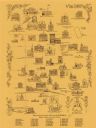
| Date: | 1970 |
|---|---|
| Description: | This pictorial map shows illustrations of historical landmarks and events, some of which include the fairgrounds, churches, the courthouse, Turner Opera Ho... |

| Date: | 1996 |
|---|---|
| Description: | This map shows roads, lakes, points of interest including colleges, trails, historic communities and sites, museums, and parks. Also included are descripti... |

| Date: | 1998 |
|---|---|
| Description: | This map shows an auto tour route with historical markers and the approximate Black Hawk Band route in southern Wisconsin. County boundaries, roads and cit... |
If you didn't find the material you searched for, our Library Reference Staff can help.
Call our reference desk at 608-264-6535 or email us at:

