 Filter: Categories of Wisconsin Historical Images
Filter: Subject of Hotels
Filter: Subject of service industries
Filter: Subject of factories
Filter: Categories of Wisconsin Historical Images
Filter: Subject of Hotels
Filter: Subject of service industries
Filter: Subject of factories

| Date: | 1896 |
|---|---|
| Description: | Bird's-eye view of Washburn, with twenty vignettes around side, water in foreground with docks and lumber corral. Thirty-three locations identified in key ... |

| Date: | 1874 |
|---|---|
| Description: | Bird's-eye view of Waukesha, looking southwest, with insets of State Industrial School, Court House, and Fountain Spring House. |

| Date: | 09 12 1919 |
|---|---|
| Description: | Looking west from the roof of the Northwestern Mutual home office at E. Wisconsin Avenue and N. Van Buren Street. City Hall is on the right. Caption on gla... |

| Date: | 06 29 1937 |
|---|---|
| Description: | A man driving an International dump truck loaded with dirt is parked in front of a park area in Niagara Falls, Ontario, Canada. The sign on the door of the... |
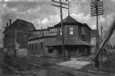
| Date: | |
|---|---|
| Description: | Railroad tracks pass by a hotel and restaurant and the Bull Durham Smoking Tobacco Factory. |
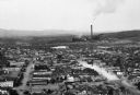
| Date: | |
|---|---|
| Description: | Elevated view of the city with a smokestack in the distance. |

| Date: | 1886 |
|---|---|
| Description: | This map has relief shown by hachures and includes a list of plats in order of date of record, laws which vacate plats, plats not shown as upon the county ... |

| Date: | 1858 |
|---|---|
| Description: | This map is hand-colored and mounted on cloth and shows lot and block numbers and dimensions, landownership, streets, railroads, selected buildings, fair g... |

| Date: | 1892 |
|---|---|
| Description: | A Sanborn map of St. Louis, which is six miles southwest of South Superior. |

| Date: | 1915 |
|---|---|
| Description: | A Sanborn fire insurance map of Sauk City created in 1915. |
If you didn't find the material you searched for, our Library Reference Staff can help.
Call our reference desk at 608-264-6535 or email us at:

