 Filter: Categories of Wisconsin Historical Images
Filter: Subject of Housing
Filter: Creator Name of Unknown
Filter: Community of Milwaukee
Filter: Categories of Wisconsin Historical Images
Filter: Subject of Housing
Filter: Creator Name of Unknown
Filter: Community of Milwaukee
| Date: | |
|---|---|
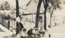
| Description: | View from street of a group of ten children sitting on the curb of a street. Behind them are a house, trees, and a man on a bicycle. Seven of the ten child... |
| Date: | |
|---|---|
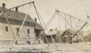
| Description: | A deserted playground with swing sets, slides, and ladders, in front of a group of buildings. There are two young boys near a dwelling in the background. |
| Date: | |
|---|---|
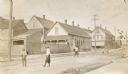
| Description: | Several boys play a street game in a residential area, two blocks away from the deserted playground. |
| Date: | |
|---|---|
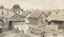
| Description: | Elevated view of backyard areas, including some dilapidated houses and outbuildings. There are wood fences surrounding some of the yards, and laundry hangs... |
| Date: | |
|---|---|
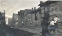
| Description: | Children having a stone fight in an unpaved alley or street in an underprivileged neighborhood. Some of the boys are holding trash can lids as protection, ... |

| Date: | |
|---|---|
| Description: | Stereograph of southwest facade on Martin Street. Built circa 1872. Architect was E.T. Mix. Dirt road in front, and the tower of the Immanuel Church is in... |
| Date: | 1918 |
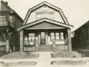
|---|---|
| Description: | View from street of Willms home, 2025 S. 31st Street, Milwaukee. Home of Kunigunde (Dorn) Willms (1857-1941) and her daughters Anna (b. 1881) and Emma (189... |

| Date: | 1836 |
|---|---|
| Description: | This map shows settlers houses and businesses, trails, and swamps. The relief is shown by hachures. The map includes illustrations of historical buildings ... |

| Date: | 1890 |
|---|---|
| Description: | Map of Milwaukee as remembered by "Dr Enoch Chase, U.B. Smith & Others." Represented are major roads, lowlands, trails, homesteads, and lots. Map depicts t... |

| Date: | 1840 |
|---|---|
| Description: | Pen-and-ink on paper. Map shows 1840’s homes with owner names, a Native American cemetery, and other points of interest. Relief shown by hachures. Oriented... |
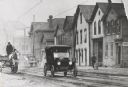
| Date: | 1918 |
|---|---|
| Description: | Street view of the north side of State Street, west of 6th Street. The second frame house from the right was once occupied as an office by Victor L. Berger... |

| Date: | 08 20 1964 |
|---|---|
| Description: | View of Mr. and Mrs. Paul Washington, standing on the sidewalk in the foreground with their backs to the camera, who were the first tenants of the Lapham P... |
If you didn't find the material you searched for, our Library Reference Staff can help.
Call our reference desk at 608-264-6535 or email us at: