 Filter: Categories of Wisconsin Historical Images
Filter: Subject of Housing
Filter: Creator Name of Unknown
Filter: Subject of rivers
Filter: Categories of Wisconsin Historical Images
Filter: Subject of Housing
Filter: Creator Name of Unknown
Filter: Subject of rivers

| Date: | 1850 |
|---|---|
| Description: | Painting depicting Chippewa Falls and the first sawmill on the Chippewa River, built by Jean Brunet. The residence of H.S. Allen, one of the owners of the... |
| Date: | 1948 |
|---|---|
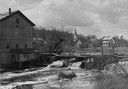
| Description: | Elevated view from shoreline towards the opposite shoreline towards the Buettner mill on the left, and the river with a dam, on the right. In the backgroun... |
| Date: | 06 1862 |
|---|---|
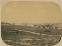
| Description: | The 7th Wisconsin Volunteer Infantry Regiment camp outside of Fredericksburg on the east side of the Rappahannock. Fredericksburg and a pontoon bridge lea... |
| Date: | |
|---|---|
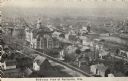
| Description: | Elevated view of town. Caption reads: "Bird's-eye View of Neillsville, Wis." |

| Date: | 1950 |
|---|---|
| Description: | Looking south. Bridge in foreground is over Kinnickinnic River. Bridge over the road holds railroad tracks. In background are several houses and a build... |

| Date: | 1901 |
|---|---|
| Description: | Elevated view looking northwest from Division Street and East Water Street. Rooftop of building in foreground has laundry hanging from a line. In the back... |

| Date: | 1964 |
|---|---|
| Description: | Marshfield Airways, covered with snow. A river full of ice and snow, with boats along the shoreline, is in the lower portion of the image. |

| Date: | |
|---|---|
| Description: | Shore-side view of the stone Conococheaque Creek Bridge with a house in the background. |
| Date: | |
|---|---|
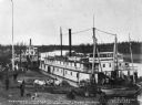
| Description: | View of several steamboats docked. Boats in the foreground are the "Lavelle Young" and "Isabelle" (text "Isabelle" partially obscured). Boat in the backgro... |

| Date: | 1915 |
|---|---|
| Description: | View of the Richmond and Dresden ferry in the Kennebec River, about to land. A man and a horse with cart are on the ferry. Several canoes and a sailboat is... |

| Date: | 1836 |
|---|---|
| Description: | This map shows settlers houses and businesses, trails, and swamps. The relief is shown by hachures. The map includes illustrations of historical buildings ... |

| Date: | 1890 |
|---|---|
| Description: | Map of Milwaukee as remembered by "Dr Enoch Chase, U.B. Smith & Others." Represented are major roads, lowlands, trails, homesteads, and lots. Map depicts t... |
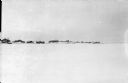
| Date: | 1918 |
|---|---|
| Description: | View across what is probably a frozen river covered with snow towards a village surrounded by a fence north of the Pinega settlement in northern Russia. |

| Date: | 1930 |
|---|---|
| Description: | This map shows rivers, lakes, trails, Indian villages, distances, and boundaries of tracts ceded by the Munnomonee, Winnebaygoes, and New York Indians Trib... |
If you didn't find the material you searched for, our Library Reference Staff can help.
Call our reference desk at 608-264-6535 or email us at: