 Filter: Categories of Wisconsin Historical Images
Filter: Subject of Indian reservations
Filter: Subject of rivers
Filter: County of Menominee
Filter: Categories of Wisconsin Historical Images
Filter: Subject of Indian reservations
Filter: Subject of rivers
Filter: County of Menominee

| Date: | 1956 |
|---|---|
| Description: | This map shows reservation boundaries, U.S. township lines, highways, roads, rivers, and lakes. The lower left corner of the map includes a legend of "Conv... |
| Date: | |
|---|---|
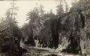
| Description: | The Dells of the Wolf River in the Menominee Indian Reservation. |
| Date: | |
|---|---|
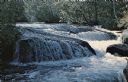
| Description: | Caption on back reads: "Neopit, Wis. Menominee Indian rocky outcroppings . . . winding falls . . . nature trail." |
If you didn't find the material you searched for, our Library Reference Staff can help.
Call our reference desk at 608-264-6535 or email us at: