 Filter: Categories of Wisconsin Historical Images
Filter: Subject of Indian reservations
Filter: Subject of rivers
Filter: Categories of Wisconsin Historical Images
Filter: Subject of Indian reservations
Filter: Subject of rivers

| Date: | 1910 |
|---|---|
| Description: | This map shows the locations of school houses, farms, roads, railroads, and Bad River Indian Reservation. Relief is shown by hachures. Yellow and red manus... |

| Date: | 1985 |
|---|---|
| Description: | This map shows mining, White River, Silver Creek, Bad River, Agogic Lake, Chequamegon Bay, smaller lakes, the Bad River Indian Reservation, and communities... |

| Date: | 1914 |
|---|---|
| Description: | This map shows township grids, railroads, roads, and drainage. The area of the map covers northeastern Wisconsin and Menominee Indian reservation. Green Ba... |

| Date: | 1840 |
|---|---|
| Description: | This map is pencil on paper and shows rivers, granite locations, and selected landmarks. Relief is shown by hachures. |

| Date: | 1994 |
|---|---|
| Description: | This map shows historical sites, picnic grounds, public boat landings, canoe and motor boat trips, and resort locations. The left margin of the map include... |

| Date: | 1790 |
|---|---|
| Description: | This map of the north eastern states shows roads, rivers, lakes, waterfalls, mountains, cities, forts, mills, the Oneida Reservation, and "New York Donatio... |

| Date: | 1795 |
|---|---|
| Description: | Detailed map of New York, showing counties, cities, mines, mills, roads, swamps, mountains, lakes and rivers. The map also shows Native American towns and ... |

| Date: | |
|---|---|
| Description: | A map of the Apostle Islands, including the harbor of Bayfield and its surroundings. |

| Date: | 1950 |
|---|---|
| Description: | A young woman is posing sitting on a boulder on the shoreline along a river rapids. She is holding a walking stick and is wearing a romper. The description... |
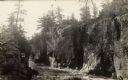
| Date: | |
|---|---|
| Description: | The Dells of the Wolf River in the Menominee Indian Reservation. |
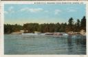
| Date: | 1953 |
|---|---|
| Description: | View upriver across water towards the Big Eddy Falls on the Wolf River. A group of people are standing on the right bank. Caption reads: "Big Eddy Falls, M... |

| Date: | |
|---|---|
| Description: | Caption on back reads: "Neopit, Wis. Menominee Indian rocky outcroppings . . . winding falls . . . nature trail." |

| Date: | 1854 |
|---|---|
| Description: | A sketch of the public surveys of Wisconsin and territory of Minnesota. |
If you didn't find the material you searched for, our Library Reference Staff can help.
Call our reference desk at 608-264-6535 or email us at:
