 Filter: Categories of Wisconsin Historical Images
Filter: Subject of Indian reservations
Filter: Year of 1900-1999
Filter: Year of 1940-1949
Filter: Categories of Wisconsin Historical Images
Filter: Subject of Indian reservations
Filter: Year of 1900-1999
Filter: Year of 1940-1949
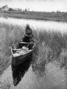
| Date: | 1941 |
|---|---|
| Description: | Joe Stoddard of the Chippewa tribe harvesting wild rice on the Bad River Indian Reservation. |

| Date: | 1940 |
|---|---|
| Description: | Slightly elevated view of a Menominee Ceremony, possibly the beginning of a dance. |
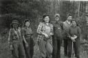
| Date: | 1943 |
|---|---|
| Description: | Ribes eradication crew of Indian women on the Menominee Reservation pose together in a line. |

| Date: | 1941 |
|---|---|
| Description: | Wisconsin counties, towns, cities, and selected villages, as well as the Menominee Indian Reservation are identified on this U.S. Bureau of the Census map ... |

| Date: | 1944 |
|---|---|
| Description: | This nine-part map from the U.S. Bureau of Public Roads identifies federal and state highways in Wisconsin by pavement type. County, forest, park, and publ... |

| Date: | 1940 |
|---|---|
| Description: | This blue line print map traced from aerial survey mosaic shows reservation boundary, roads, trails, and railroads. Color manuscript annotations show triba... |
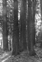
| Date: | 1940 |
|---|---|
| Description: | Lear Shewano is dwarfed by a grove of huge virgin white pine trees in the Menominee Indian Reservation. He is wearing a white hat and plaid shirt. |
If you didn't find the material you searched for, our Library Reference Staff can help.
Call our reference desk at 608-264-6535 or email us at: