 Filter: Categories of Wisconsin Historical Images
Filter: Subject of Indians of North America
Filter: County of Sawyer
Filter: Categories of Wisconsin Historical Images
Filter: Subject of Indians of North America
Filter: County of Sawyer

| Date: | 1900 |
|---|---|
| Description: | This map of Sawyer County, Wisconsin, shows the numbered "sub-school-districts of the town of Hayward" school houses, and the Indian reservation. The towns... |

| Date: | 1902 |
|---|---|
| Description: | This 1902 map of the eastern portion of Sawyer County, Wisconsin, shows the township and range system, sections, roads, farm houses, camps, school houses, ... |

| Date: | 1919 |
|---|---|
| Description: | This 1919 map of Sawyer County, Wisconsin, shows the township and range system, sections, cities and villages, roads, railroads, farm houses, the Indian re... |
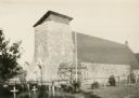
| Date: | 1933 |
|---|---|
| Description: | The Catholic church of St. Francis Solanus is located on the Lac Courte Oreilles reservation. The church was built 1923-1924 of native pipestone under the ... |

| Date: | 1911 |
|---|---|
| Description: | This map shows lakes, rivers, swamps, state swamp land, trails and railroads. Includes a township diagram. |

| Date: | 1975 |
|---|---|
| Description: | This map shows boundaries, roads, national forest land, bogs and wetlands, lakes, campgrounds, and boat landings. |

| Date: | 1910 |
|---|---|
| Description: | This blue print map shows original lakes, area to be covered by Chippewa Flowage (flow-lines for contours 1310 and 1315), dam sites, roads, and buildings. |
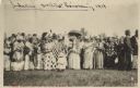
| Date: | 06 19 1919 |
|---|---|
| Description: | A gathering of Native American women, some holding flags, to welcome home soldiers returning from WWI on Corpus Christi Day. There are men in the backgroun... |

| Date: | 1940 |
|---|---|
| Description: | This blue line print map traced from aerial survey mosaic shows reservation boundary, roads, trails, and railroads. Color manuscript annotations show triba... |
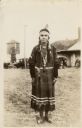
| Date: | 1934 |
|---|---|
| Description: | Full-length portrait of a Native American Woman (Ojibwa) wearing traditional dress. Caption reads: "Chippewa Indian Squaw, Hayward, Wis." |
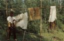
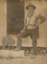
| Date: | |
|---|---|
| Description: | Ojibwa man tanning a hide outdoors. Text on reverse reads: "Here at Historyland you can see the Chippewa Indians in their colorful native dress and natu... |
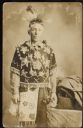
| Date: | 1910 |
|---|---|
| Description: | Studio portrait of a man who is a member of the Lac Courte Oreilles band of the Lake Superior Chippewa (Ojibwe). He is wearing a feathered headdress, a bea... |
| Date: | 10 15 1907 |
|---|---|
| Description: | Outdoor portrait of a man standing outside the open door of a wooden home with one hand on his hip, and in his other hand holding what may be a pipe restin... |
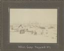
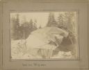
| Date: | 1910 |
|---|---|
| Description: | View of multiple structures in winter, with bare trees and stumps among them. A wigwam/wiigiwaam is visible in the distance, and a tipi is closer. A log st... |
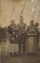
| Date: | 1910 |
|---|---|
| Description: | Outdoor group portrait of four Lac Courte Oreilles people: Mrs. [Lucille Mike] Kingfisher, Mitchell Quagon, with a pipe in his mouth, Lizzie Quagon, his wi... |
| Date: | 1910 |
|---|---|
| Description: | Wigwam\wiigiwaam that is partially uncovered, outdoors on snow-covered ground with trees in the background. |
If you didn't find the material you searched for, our Library Reference Staff can help.
Call our reference desk at 608-264-6535 or email us at:

