Filter: Categories of Wisconsin Historical Images
Filter: Subject of Islands
Filter: Type of Map or Atlas
Filter: Year of 1900-1999
Filter: Year of 1970-1979
Filter: Categories of Wisconsin Historical Images
Filter: Subject of Islands
Filter: Type of Map or Atlas
Filter: Year of 1900-1999
Filter: Year of 1970-1979

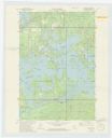
| Date: | 1971 |
|---|---|
| Description: | A topographical map of Namekagon Lake and the surrounding area. |

| Date: | 1975 |
|---|---|
| Description: | Colored bird's-eye map of the Lake Region of Waukesha County. Looking North from Government Hill. All these Lakes and Resorts are withing Four hours ride o... |
If you didn't find the material you searched for, our Library Reference Staff can help.
Call our reference desk at 608-264-6535 or email us at: