 Filter: Categories of Wisconsin Historical Images
Filter: Subject of Lakes
Filter: Creator Name of Chicago and Northwestern Railway Co.
Filter: Categories of Wisconsin Historical Images
Filter: Subject of Lakes
Filter: Creator Name of Chicago and Northwestern Railway Co.

| Date: | 1903 |
|---|---|
| Description: | A map of northern Wisconsin and Michigan showing the names and locations hunting and fishing resorts in the area, as well as location of Chicago and North ... |

| Date: | 1904 |
|---|---|
| Description: | A map that shows the location of the lakes and resorts in northeastern Wisconsin that were reachable by the Chicago and North Western Railway. Shown in the... |

| Date: | 1909 |
|---|---|
| Description: | A brochure with a map showing the North-Western Railway lines from northern Illinois, starting at Chicago, to southeastern Wisconsin, stopping at Sheboygan... |

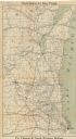
| Date: | 1914 |
|---|---|
| Description: | Two maps of northern Wisconsin counties of Ashland, Barron, Bayfield, Chippewa, Douglas, Forest, Iron, Langlade, Lincoln, Oneida, Polk, Price, Sawyer, Tayl... |

| Date: | 1900 |
|---|---|
| Description: | This map of shows the township grid, counties, cities and villages, lakes, rivers, rail lines and the Menominee Indian Reservation. |
| Date: | 1909 |
|---|---|
| Description: | This map shows the Chicago and North Western Railway lines in eastern Wisconsin, north to Wausau and Oconto and west to Baraboo and Blue Mounds, and northe... |

| Date: | 1910 |
|---|---|
| Description: | This map of northeastern Wisconsin shows the township grid, counties, cities and villages, lakes, rivers, rail lines and the Menominee Indian Reservation. ... |

| Date: | 1904 |
|---|---|
| Description: | A brochure for the lake region of north-eastern Illinois and south-eastern Wisconsin providing information on summer activities and places to stay in the a... |
If you didn't find the material you searched for, our Library Reference Staff can help.
Call our reference desk at 608-264-6535 or email us at: