 Filter: Categories of Wisconsin Historical Images
Filter: Subject of Lakes
Filter: Creator Name of Unknown
Filter: Categories of Wisconsin Historical Images
Filter: Subject of Lakes
Filter: Creator Name of Unknown

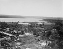
| Date: | 1910 |
|---|---|
| Description: | Bird's-eye view. Caption reads: "Madison, Wis. and the Four Lake Region." |
| Date: | 1905 |
|---|---|
| Description: | A group of three people are sitting at the fountain, and another group of three people are in the background behind the fountain. Caption reads: "Fountain ... |
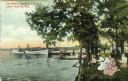
| Date: | 1905 |
|---|---|
| Description: | View from shoreline of a steamboat landing on Lake Geneva. A group of women are gathered on the shore in the foreground. Caption reads: "Steamboat Landing,... |

| Date: | 1934 |
|---|---|
| Description: | Aerial view of Capitol and Lake Mendota and Lake Monona. |

| Date: | 1928 |
|---|---|
| Description: | Aerial view of Madison looking southeast over the isthmus, showing the Four Lakes Country. Visible at the bottom is the Lake Mendota shoreline. At center, ... |

| Date: | 1948 |
|---|---|
| Description: | Aerial view of the Wisconsin State Capitol and surrounding area looking south southeast towards Lake Monona. |

| Date: | 1950 |
|---|---|
| Description: | Aerial view of the Madison isthmus looking north. Caption reads: "Madison Wisconsin — Between Lake Mendota and Lake Monona". |

| Date: | 1919 |
|---|---|
| Description: | Colorized aerial view of isthmus looking northwest over the Wisconsin State Capitol. Caption reads: "Aeroplane View, Madison, Wis., and State Capitol." |

| Date: | 1924 |
|---|---|
| Description: | Aerial view of Madison's Willow Beach towards the University of Wisconsin-Madison campus, downtown Madison, and Lake Monona. |

| Date: | 1930 |
|---|---|
| Description: | Aerial view above Shorewood Hills near Madison, looking northeast. |
| Date: | 1924 |
|---|---|
| Description: | Aerial view looking southwest over Madison's Vilas Park. |

| Date: | |
|---|---|
| Description: | View of a large geological rock formation at the base of a river or lake. |

| Date: | 1910 |
|---|---|
| Description: | View from water of the Angle Worm Station at the foot of Carroll Street on Lake Monona. |

| Date: | 07 06 1937 |
|---|---|
| Description: | Aerial view of the west central part of isthmus and the University of Wisconsin campus. |

| Date: | |
|---|---|
| Description: | Aerial view over the Wisconsin State Capitol looking south south-east. |

| Date: | |
|---|---|
| Description: | Anna and Edward Birge house at 744 Langdon Street. This is the current site of the Memorial Union parking lot. |

| Date: | 1911 |
|---|---|
| Description: | Plat Map of Blooming Grove in "Atlas of Dane County, Wisconsin." |
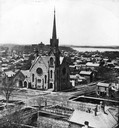
| Date: | |
|---|---|
| Description: | Elevated view of the First Congregational Church and chapel at the corner of North Fairchild Street and West Washington Avenue. The Gates of Heaven Synagog... |
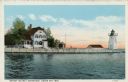
| Date: | 1920 |
|---|---|
| Description: | View across water toward the lighthouse. Caption reads: "Grassy Island Lighthouse, Green Bay, Wis." |
If you didn't find the material you searched for, our Library Reference Staff can help.
Call our reference desk at 608-264-6535 or email us at:
