 Filter: Categories of Wisconsin Historical Images
Filter: Subject of Lakes
Filter: Creator Name of Unknown
Filter: Categories of Wisconsin Historical Images
Filter: Subject of Lakes
Filter: Creator Name of Unknown
| Date: | 1945 |
|---|---|
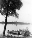
| Description: | View of the Wisconsin State Capitol from across Lake Monona with a tree, pier and boat in the foreground. |
| Date: | 1948 |
|---|---|
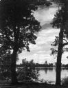
| Description: | Wisconsin State Capitol from the south side of Monona Bay. |
| Date: | 1915 |
|---|---|
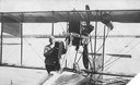
| Description: | Jack Vilas (seated) in the Curtiss hydroplane he used to spot forest fires for the Wisconsin Conservation Department. (His companion is not identified.) Th... |

| Date: | 1910 |
|---|---|
| Description: | Map of Dane County rural delivery in Madison and the town of Westport. |

| Date: | 1839 |
|---|---|
| Description: | A map of the Wiskonsin [sic] and Neenah or Fox Rivers. |

| Date: | 1910 |
|---|---|
| Description: | Map of the general plan of the district of the Four Lakes. |
| Date: | 1915 |
|---|---|
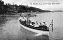
| Description: | View of a group of people in a large model launch with an American flag. Caption reads: "On Mendota Lake near University of Wisconsin-Madison Boat House." |

| Date: | 1897 |
|---|---|
| Description: | A view from the capitol looking west up State Street toward the University of Wisconsin-Madison with the Holy Redeemer Church, Holy Redeemer School, Red Gy... |
| Date: | 1880 |
|---|---|
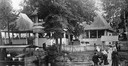
| Description: | Monona Lake Assembly, The Casino. This structure, including the ice house and provision space, designed by Conover and Porter and built for $1700.00 in Jun... |
| Date: | 1912 |
|---|---|
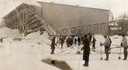
| Description: | Men harvesting ice at the Conklin Ice House on Lake Mendota. The men are using pike poles to slide the blocks to the conveyor and U-shaped tools to split p... |
| Date: | |
|---|---|
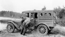
| Description: | Dr. Edward Ashael Birge reading a sun machine inside a car. In 1875 Dr. Birge first came to teach natural history at the University of Wisconsin, and remai... |
| Date: | |
|---|---|
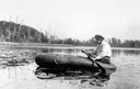
| Description: | Dr. Edward Ashael Birge paddling on a raft in Trout Lake. In 1875 Dr. Birge first came to teach natural history at the University of Wisconsin, and remaine... |
| Date: | 1912 |
|---|---|
| Description: | Dr. E.A. Birge in his element, reading an anemometer of the weather data station on Green Lake. |

| Date: | 1836 |
|---|---|
| Description: | The top map is the "Plat of Madison the Capitol of Wisconsin." The bottom map is the "Map of the Four Lake Country. Taken from the Township Maps in the U.S... |
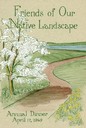
| Date: | 1969 |
|---|---|
| Description: | Cover for the 1969 Wisconsin Friends of Our Native Landscape program. Depicted is a tree with white blossoms, yellow flowers, and a pathway leading up to a... |

| Date: | 1960 |
|---|---|
| Description: | Cover for the 1960 Wisconsin Friends of Our Native Landscape program. Depicted are some vibrant purple flowers, with a lake in the background. The Wisconsi... |
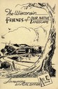
| Date: | 1948 |
|---|---|
| Description: | Cover for the 1948 Wisconsin Friends of Our Native Landscape program. Depicted is a sketch of a tree, a fence, and a small town by a lake. The Wisconsin Fr... |
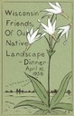
| Date: | 1956 |
|---|---|
| Description: | Cover for the 1956 Wisconsin Friends of Our Native Landscape program. Depicted are some white flowers with green leaves, a lake, and some birds flying in t... |

| Date: | 1870 |
|---|---|
| Description: | Bird's-eye map of Madison. The Lakeside House resort is in the foreground, which burned in 1877, in what is now Olin Park. |

| Date: | 1868 |
|---|---|
| Description: | Bird's-eye map of Manitowoc, with four insets. Manitowoc County. |
If you didn't find the material you searched for, our Library Reference Staff can help.
Call our reference desk at 608-264-6535 or email us at: