 Filter: Categories of Wisconsin Historical Images
Filter: Subject of Lakes
Filter: County of Brown
Filter: Categories of Wisconsin Historical Images
Filter: Subject of Lakes
Filter: County of Brown
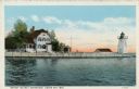
| Date: | 1920 |
|---|---|
| Description: | View across water toward the lighthouse. Caption reads: "Grassy Island Lighthouse, Green Bay, Wis." |
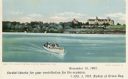
| Date: | 11 10 1905 |
|---|---|
| Description: | A group of people are in a motorboat, named "Quo Vadis,, in the lake in front of St. Joseph's orphan asylum. Caption reads: "St. Joseph's Orphan Asylum, Gr... |
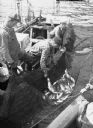
| Date: | 1936 |
|---|---|
| Description: | Three commercial fishermen in a boat lifting a trap net. In the bottom right foreground are the hands of another man holding the opposite side of the net f... |

| Date: | 1835 |
|---|---|
| Description: | Ink on tracing paper map of Green Bay, Wisconsin and nearby areas, Lake Winnebago, Fox and Wolf Rivers, and the junctions of the Mississippi and Wisconsin ... |
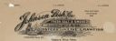
| Date: | |
|---|---|
| Description: | Memohead of the Johnson Fish Company of Green Bay, Wisconsin, wholesalers of "fresh. salt. & smoked fish, oysters and live crawfish," with a fish being pul... |

| Date: | 1890 |
|---|---|
| Description: | These hand-colored maps show the sections, lakes, swamps, streams, and state, vacant, entered, and withdrawn lands in ten survey townships in Oneida, Vilas... |

| Date: | 1908 |
|---|---|
| Description: | This 1908 map shows the township and range grid, sections, towns, villages, railroads, bridges, lakes, streams, rapids, and state-owned lands in Oneida Cou... |

| Date: | 1959 |
|---|---|
| Description: | This map identifies public forest land and industrial forest land as of 1959 in Oneida County, Wisconsin, using a 1930 base map showing the township and ra... |

| Date: | 1930 |
|---|---|
| Description: | These 40 hand-drawn maps depict the survey townships in Oneida County, Wisconsin, on printed township grids. Lakes, rivers, and waterfront properties are d... |

| Date: | 1903 |
|---|---|
| Description: | Map of Brown County, Wisconsin, shows the township and range grid, towns, sections, cities, villages and post offices, land owners and acreages, railroads,... |
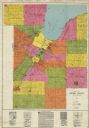
| Date: | 1930 |
|---|---|
| Description: | This early-mid 20th century map of Brown County, Wisconsin, shows the township and range grid, towns, sections, cities and villages, land owners and acreag... |

| Date: | 1951 |
|---|---|
| Description: | This map has depths shown by bathymetric tints and soundings and relief shown by contours, the depths are shown in feet. There is an inset map of Green Bay... |

| Date: | 1931 |
|---|---|
| Description: | View of a sunset over a lake with trees along the shoreline. Caption reads: "Greetings from Denmark, Wis." |
If you didn't find the material you searched for, our Library Reference Staff can help.
Call our reference desk at 608-264-6535 or email us at: