Filter: Categories of Wisconsin Historical Images
Filter: Subject of Lakes
Filter: County of Calumet
Filter: Categories of Wisconsin Historical Images
Filter: Subject of Lakes
Filter: County of Calumet
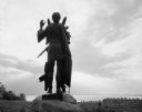
| Date: | 1963 |
|---|---|
| Description: | Statue of Winnebago Indian Chief Red Bird, with Lake Winnebago in the background. |
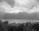
| Date: | 08 11 1963 |
|---|---|
| Description: | Elevated view of the northern end of Lake Winnebago, seen from High Cliff State Park. The sunset is subdued by a large cloud formation over the lake. On th... |
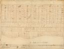
| Date: | |
|---|---|
| Description: | This map, which was likely drawn in the mid-19th century, shows land ownership on the Stockbridge Reservation on the shore of Lake Winnebago in what is now... |
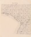
| Date: | 1943 |
|---|---|
| Description: | Map shows the town of St. Catherine, Wisconsin, between Lake Street and Doty Street as it appeared on January 3, 1852. Map is situated facing north with La... |
| Date: | 1955 |
|---|---|
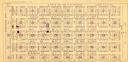
| Description: | This map shows landownership in the old Stockbridge Indian reservation on Lake Winnebago in Calumet County. The lots are numbered and labeled by owner. A b... |

| Date: | 1836 |
|---|---|
| Description: | This negative photostat map shows the "oak tree, place of beginning" on the division line between Stockbridge and Brothertown Indians, and Governor Porter'... |

| Date: | 1974 |
|---|---|
| Description: | This map draws content from a map originally created by George Featherstongaugh in 1840. The map shows streets, land ownership, the Brotherton Indian reser... |

| Date: | 1990 |
|---|---|
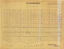
| Description: | This map includes two insets: Plat of New Holstein village and Village of Chilton. The map also includes a table of statistics showing the assessed value o... |
| Date: | 1982 |
|---|---|
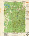
| Description: | This standard U.S.G.S. topographic map was annotated by civil engineer and railroad historian James P. Kaysen to show the location of existing and defunct ... |
| Date: | 1939 |
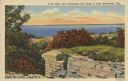
|---|---|
| Description: | Caption reads: "High Cliff overlooking East Shore of Lake Winnebago, Wis." Elevated view of Lake Winnebago from High Cliff State Park. A stone outcropping ... |
If you didn't find the material you searched for, our Library Reference Staff can help.
Call our reference desk at 608-264-6535 or email us at: