 Filter: Categories of Wisconsin Historical Images
Filter: Subject of Lakes
Filter: County of Florence
Filter: Categories of Wisconsin Historical Images
Filter: Subject of Lakes
Filter: County of Florence

| Date: | 1910 |
|---|---|
| Description: | Elevated view of Florence from across Fisher Lake, with several people standing below on the shoreline. Caption reads: "Florence, Wis. from across Fisher L... |

| Date: | 1890 |
|---|---|
| Description: | Field and trees and water are in the foreground. On the far shoreline are buildings in the town. |

| Date: | 1891 |
|---|---|
| Description: | Map shows Iron and Dickinson Counties, Mich. and Florence County, Wis. "Nov. 1st, 1891." Irregularly shaped. Includes table of distances and township diagr... |

| Date: | 1907 |
|---|---|
| Description: | Shows roads, railroads, lakes, rivers, churches, and camps. |
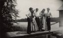
| Date: | 1890 |
|---|---|
| Description: | A group of three men and two women are standing on a pier inspecting a 15 pound muskellunge. Long Lake is in the background. There is a boathouse at the en... |

| Date: | 1960 |
|---|---|
| Description: | This map shows uplands and swamps owned by the Goodman Lumber Division, water, and roads. The lower right corner includes a location map. The upper left co... |
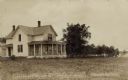
| Date: | |
|---|---|
| Description: | View across lawn towards a two-story dwelling next to a lake. Three people are sitting in the screened-in porch. Caption reads: "A.J. Larson's Residence, L... |
If you didn't find the material you searched for, our Library Reference Staff can help.
Call our reference desk at 608-264-6535 or email us at: