 Filter: Categories of Wisconsin Historical Images
Filter: Subject of Lakes
Filter: County of Kenosha
Filter: Categories of Wisconsin Historical Images
Filter: Subject of Lakes
Filter: County of Kenosha
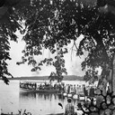
| Date: | 1878 |
|---|---|
| Description: | View from shoreline of a large crowd on a pier waiting for a crowded steam excursion boat. |

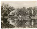
| Date: | 1878 |
|---|---|
| Description: | People seated in a small steamboat tied at a pier on a lake. A flag flies from the bow and there is a two-story frame house on the shore. This photograph m... |
| Date: | |
|---|---|
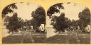
| Description: | Several men and women sit outdoors on the grounds of Bain's Camp in Twin Lakes, Wisconsin. |
| Date: | |
|---|---|
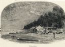
| Description: | Engraving of a wooden shack on a Lake Michigan beach surrounded by rowboats, a campfire, and a wooded bluff. Two men stand on the beach near the water. |

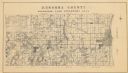
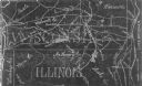
| Date: | 1946 |
|---|---|
| Description: | A map showing the roads, railroads, towns, cities and villages, streams and lakes, airports, schools, churches, cemeteries, and golf courses in Kenosha Cou... |

| Date: | 1892 |
|---|---|
| Description: | This map shows the dams and locks of the Fox River between Neenah, in Winnebago County, Wisconsin, and Kaukauna, in Outagamie County. The cities and villag... |

| Date: | 1906 |
|---|---|
| Description: | This map, which shows the Mascoutin village site near Berlin, Wisconsin, the Fox River, and parts of the Wisconsin and Wolf Rivers, was published in the Pr... |

| Date: | 1905 |
|---|---|
| Description: | This pictorial representation of part of Lake Winnebago and the Fox River in 1703, showing interactions between white beaver hunters and the Iroquois is ta... |

| Date: | 1850 |
|---|---|
| Description: | A map which includes the ink and pencil annotations showing the sections, sold parcels of land, and streams and lakes on a printed township base map for To... |
| Date: | 1934 |
|---|---|
| Description: | A land inventory map of Kenosha County. The top left features a legend of "Land Cover" and "Roads and Other Improvements". Lake Michigan is labelled to the... |

| Date: | 1959 |
|---|---|
| Description: | This map shows public access sites, public beaches and parks, other public shorelines, boat liveries, public hunting and fishing grounds, railroads, roads,... |
| Date: | 1954 |
|---|---|
| Description: | This photocopy map shows a early sketch of the settlement Southport. Rivers, lakes, other settlements, county boundaries, and roads are labeled. A portion ... |
| Date: | |
|---|---|
| Description: | A holiday card featuring Lake Dunmovin on the Zerk estate. The mansion is in the background on the left. On the opposite shoreline on the right is an arche... |
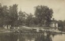
| Date: | 1912 |
|---|---|
| Description: | Text on front reads: "Lake House, Twin Lakes, Wis." A group of people are gathered on the lawn at the shore of the lake. Two seated people hold a pennant t... |
If you didn't find the material you searched for, our Library Reference Staff can help.
Call our reference desk at 608-264-6535 or email us at: