 Filter: Categories of Wisconsin Historical Images
Filter: Subject of Lakes
Filter: County of Marathon
Filter: Categories of Wisconsin Historical Images
Filter: Subject of Lakes
Filter: County of Marathon
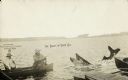
| Date: | 08 05 1922 |
|---|---|
| Description: | Two fishermen on a lake catch a giant fish. Both of the fishermen are wearing hats and one is smoking a pipe. A dock and the tip of a boat are in the foreg... |
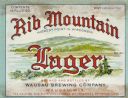
| Date: | 1938 |
|---|---|
| Description: | Label submitted to the state of Wisconsin for trademark registration. "Rib Mountain Lager, Highest Point in Wisconsin, Brewed and Bottled by Wausau Brewing... |

| Date: | 1939 |
|---|---|
| Description: | Label submitted to the state of Wisconsin for trademark registration. "Superfine Marathon Beer, Marathon City Brewing Company." In the foreground of the im... |

| Date: | 1965 |
|---|---|
| Description: | Map shows original plat, plat additions, and lot measurements for Rothschild, Wisconsin. Lake Wausau and the Wisconsin River are labelled. Map reads: "Comp... |
| Date: | 1954 |
|---|---|
| Description: | This map of Wausau is pink, red, gray, and white. The map includes indexes of streets, industries, and community buildings and features a photograph of the... |

| Date: | 1917 |
|---|---|
| Description: | Three women sit in the back of a Hudson Touring car, while a fourth woman stands behind the car on the side rail. All four women wear scarves over their ha... |

| Date: | 1913 |
|---|---|
| Description: | Woman, possibly Marvin B. Rosenberry's daughter (?), picking flowers in a field near a lake. |

| Date: | 1982 |
|---|---|
| Description: | Color map. "Topography by photogrammetric methods from aerial photographs taken 1963. Revised from aerial photographs taken 1978. Field checked 1979. Map e... |

| Date: | 1915 |
|---|---|
| Description: | This map is mounted on cloth and shows lots and landownership, selected buildings, roads, railroads, parks, cemeteries, city wards, and includes advertisem... |

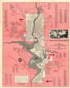
| Date: | 1951 |
|---|---|
| Description: | This map shows land use, dwellings, resorts, camps, marshes, springs, dams, lake bottom composition, and access. The map includes a fish species table, geo... |
If you didn't find the material you searched for, our Library Reference Staff can help.
Call our reference desk at 608-264-6535 or email us at: