Filter: Categories of Wisconsin Historical Images
Filter: Subject of Lakes
Filter: County of Oneida
Filter: Year of 1900-1999
Filter: Categories of Wisconsin Historical Images
Filter: Subject of Lakes
Filter: County of Oneida
Filter: Year of 1900-1999

| Date: | 07 10 1949 |
|---|---|
| Description: | Aerial view of Minocqua showing the surrounding lakes. |

| Date: | 1905 |
|---|---|
| Description: | Caption reads: Panoramic View of Minocqua, Wis." A railroad bridge is in the foreground. |

| Date: | 1916 |
|---|---|
| Description: | Elevated view of the town from a boxcar. A railroad train is headed towards a bridge over the lake. Caption reads: The ideal fishing resort of the One Thou... |

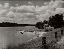
| Date: | 09 27 1942 |
|---|---|
| Description: | Labeled as a "freak" snowstorm. A boathouse takes up the majority of the image, with a flag flying over the boathouse. The lake is not frozen, but ice and... |

| Date: | 1907 |
|---|---|
| Description: | View from water of the Chicago Milwaukee and St. Paul railroad bridge. Probably over a stretch of Kawaguasaga Lake. There is a stairway leading to the wate... |
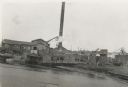
| Date: | 1939 |
|---|---|
| Description: | A view from water of the Thunder Lake Lumber Co., one of the largest sawmills in Rhinelander. It was located on Lake Creek and operated until 1937. |

| Date: | 1920 |
|---|---|
| Description: | This early 1920s map shows state-owned land in townships 38 and 39, range 7 east, the towns of Lake Tomahawk and Woodruff, in Oneida County, Wisconsin, tha... |

| Date: | 1915 |
|---|---|
| Description: | This 1915 map shows railroads, wagon roads, trails, creeks, rivers, lakes, and trout streams in Oneida and Lincoln counties within a 12 mile radius of Rhin... |
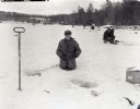
| Date: | 01 23 1957 |
|---|---|
| Description: | Steve Meleski kneeling near his ice fishing hole at Thunder lake. Other people are fishing on the lake behind him. The shoreline is wooded, and there are b... |
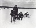
| Date: | 01 23 1957 |
|---|---|
| Description: | Lee Jameson, Walter Jameson, and Jim Stern clearing an ice fishing hole in Thunder Lake. |

| Date: | 1900 |
|---|---|
| Description: | This map of Three Lakes shows forest fire lookout towers, picnic grounds, an airport, roads, and railroad. The map features text boxes on the Village of Th... |
| Date: | 08 05 1916 |
|---|---|
| Description: | View across water of The Narrows in Trout Lake. There are people in a canoe out on the lake. Caption reads: "'The Narrows' Trout Lake, Wood Cliff, Wis." |

| Date: | 01 1969 |
|---|---|
| Description: | A map of Oneida county, which includes a small drawing of a hodag. |

| Date: | 1962 |
|---|---|
| Description: | This map shows roads, golf courses, ski areas, boat landings, camp sites, waysides, parks, beaches, scenic views, virgin timber tracts, airports, boys and ... |

| Date: | 1900 |
|---|---|
| Description: | This map shows logging roads, railroads with spur lines, trails, rapids, lumber camps, Indian villages, summer resort, lakes, rivers, and ponds. |

| Date: | 1940 |
|---|---|
| Description: | This map shows lakes, roads, car trails, foot trails, railroads, resorts and camps, and fire towers. The map includes an inset location map and pictorial d... |
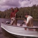
| Date: | 1963 |
|---|---|
| Description: | A man is standing in a boat on Pine Lake, holding up a muskellunge he has caught. Another man is sitting in the boat holding a camera to take a photograph ... |
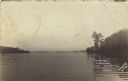
| Date: | 09 1971 |
|---|---|
| Description: | Elevated view from forested hill towards Carrol Lake. |

| Date: | 1935 |
|---|---|
| Description: | An unidentified man standing on a lawn is holding a 48 pound muskie by a wood handled hook. There is a lake in the background, and on the right, the rustic... |
If you didn't find the material you searched for, our Library Reference Staff can help.
Call our reference desk at 608-264-6535 or email us at: