 Filter: Categories of Wisconsin Historical Images
Filter: Subject of Lakes
Filter: County of Portage
Filter: Categories of Wisconsin Historical Images
Filter: Subject of Lakes
Filter: County of Portage
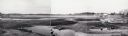
| Date: | 1958 |
|---|---|
| Description: | Plover River Pond; the dam was out and the pond is dry, permitting an unusual view of the immediate area. Highway 51 and a bridge can be seen in the distan... |

| Date: | |
|---|---|
| Description: | This map from the early 20th century shows the township and range grid, towns, sections, cities and villages, railroads, roads, schools, churches, cemeteri... |

| Date: | 1936 |
|---|---|
| Description: | This manuscript map shows the route traveled by the Schoolcraft expedition in July 1831 between the Namekagon River and Lake Owen in the Town of Cable, Bay... |
If you didn't find the material you searched for, our Library Reference Staff can help.
Call our reference desk at 608-264-6535 or email us at:
