 Filter: Categories of Wisconsin Historical Images
Filter: Subject of Lakes
Filter: Subject of water
Filter: County of Juneau
Filter: Categories of Wisconsin Historical Images
Filter: Subject of Lakes
Filter: Subject of water
Filter: County of Juneau

| Date: | 1957 |
|---|---|
| Description: | Aerial view of town including water tower, city streets, houses, and other buildings. |

| Date: | 03 16 1949 |
|---|---|
| Description: | Aerial view of Mauston, Wisconsin. |
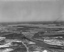
| Date: | 04 16 1949 |
|---|---|
| Description: | Aerial view of Petenwell Dam and dike on Wisconsin River twenty miles north of Necedah, Wisconsin showing the early formation of Lake Petenwell. |
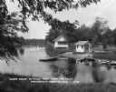
| Date: | 1930 |
|---|---|
| Description: | Campgrounds at the Island Resort, located 25 miles west of the Wisconsin Dells. |
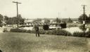
| Date: | |
|---|---|
| Description: | View looking north across the Highway 21 bridge at Necedah Lake. A man, likely a Resettlement Administration worker, poses in the grass in the foreground. |
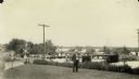
| Date: | 1935 |
|---|---|
| Description: | View looking north across the Highway 21 bridge at Necedah Lake. A man, likely a Resettlement Administration worker, stands holding a pipe in the foregroun... |

| Date: | 1876 |
|---|---|
| Description: | A hand-colored map on six sheets, this map of Juneau County indicates the locations of townships and sections, landowners and acreages, roads, wagon roads,... |
If you didn't find the material you searched for, our Library Reference Staff can help.
Call our reference desk at 608-264-6535 or email us at: