 Filter: Categories of Wisconsin Historical Images
Filter: Subject of Land
Filter: Creator Name of Foster, Mary Stuart
Filter: Categories of Wisconsin Historical Images
Filter: Subject of Land
Filter: Creator Name of Foster, Mary Stuart

| Date: | 1919 |
|---|---|
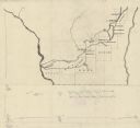
| Description: | This map depicts the route of the 1842 overland trip by wagon made by the Reverend Alfred Brunson and some copper miners from Prairie du Chien to the mouth... |

| Date: | 1942 |
|---|---|
| Description: | These three maps depict the locations of French missions and French forts in Wisconsin, as well as the French place names in the state. |

| Date: | 1935 |
|---|---|
| Description: | This map shows Wisconsin’s pinery region. Lake Superior, Lake Michigan, Lake Winnebago, Green Bay, the Wisconsin River, and the Mississippi River are label... |
| Date: | 1935 |
|---|---|
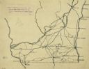
| Description: | This manuscript map shows route of the early military road in Wisconsin from Green Bay (Fort Howard) through Portage (Fort Winnebago) to Fort Blue Mounds a... |

| Date: | 1920 |
|---|---|
| Description: | Shows 10 land and water trails along rivers and other bodies of water in northern Wisconsin and the Upper Peninsula of Michigan; each trail numbered and de... |

| Date: | 1942 |
|---|---|
| Description: | This map shows the Wisconsin and Fox River routes in green, and the Milwaukee and Rock River Canal routes in red. Prairie du Chien, Fort Winnebago, Grand C... |
| Date: | 1922 |
|---|---|
| Description: | An ink on tracing paper, hand-drawn of south and eastern Wisconsin, illustrating the roads ranging from Dubuque, Iowa in the east to Green Bay, Wisconsin i... |
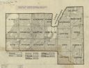
| Date: | 1922 |
|---|---|
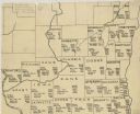
| Description: | A hand-sketched map representing 1850 data of southern and eastern Wisconsin displaying the demographical breakouts for the counties in those areas, showin... |
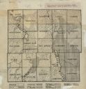
| Date: | 1918 |
|---|---|
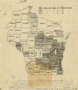
| Description: | This map is ink on tracing paper showing all the counties of Wisconsin. The upper right hand corner contains a legend for distinguishing Wisconsin counties... |
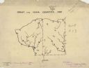
| Date: | 1927 |
|---|---|
| Description: | A hand-drawn map outlining the counties of Grant and Iowa counties as they would have appeared in 1837. |

| Date: | 1920 |
|---|---|
| Description: | An ink on tracing paper, hand-drawn map that shows lead mines, the boundary of the lead bearing strata, and the military road in Lafayette, Grant, Iowa, an... |
| Date: | 1922 |
|---|---|
| Description: | This early 20th century manuscript map shows prairie, maple, maple and beech, marsh conifer, oak, oak and maple, and grass and sedge areas by town in Dodge... |
| Date: | 1930 |
|---|---|
| Description: | Map shows prairie, oak, maple, oak and maple, marsh conifer, maple and beech, and grass and sedge. |

| Date: | 1972 |
|---|---|
| Description: | Ink on tracing paper. This map shows rivers, Prairie du Chien, site of Fort Crawford, Excelsior, Fort Andrew, Boscobel, Blue River, Orion, Muscoda, Castle ... |
If you didn't find the material you searched for, our Library Reference Staff can help.
Call our reference desk at 608-264-6535 or email us at: