 Filter: Categories of Wisconsin Historical Images
Filter: Subject of Land
Filter: Creator Name of Griswold, C. J.
Filter: Categories of Wisconsin Historical Images
Filter: Subject of Land
Filter: Creator Name of Griswold, C. J.
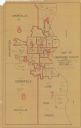
| Date: | 1938 |
|---|---|
| Description: | Map shows wards and assembly districts for Milwaukee County as of September 1938. The map contains annotations in what appears to be pencil showing senator... |
If you didn't find the material you searched for, our Library Reference Staff can help.
Call our reference desk at 608-264-6535 or email us at: