Filter: Categories of Wisconsin Historical Images
Filter: Subject of Land
Filter: County of Calumet
Filter: Categories of Wisconsin Historical Images
Filter: Subject of Land
Filter: County of Calumet

| Date: | 1878 |
|---|---|
| Description: | Bird's-eye map of Chilton with insets of points of interest, including P.H. Becker's Brewery, Chilton House, and Gutheil's Block. |

| Date: | 10 10 1947 |
|---|---|
| Description: | Aerial view of Dundas cannery. |
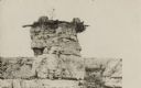
| Date: | 12 10 1907 |
|---|---|
| Description: | Photographic postcard of a rock formation with two tree stumps and plants on top. Gravel and scrub vegetation are in the background. Text below reads: "Sce... |
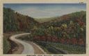
| Date: | 1947 |
|---|---|
| Description: | Colorized postcard of a paved road curving between hills with trees in autumn color. There are flowers in the fields on both sides of the road. Caption rea... |

| Date: | |
|---|---|
| Description: | Color postcard of a man sitting on a stone wall along a road while enjoying a country scene. The road curves through the hills and the trees are starting t... |
| Date: | |
|---|---|
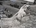
| Description: | View of a farmer from top of straw stack. The man uses a fork to push down the straw as more is being blown onto the pile from a thresher. More men in work... |

| Date: | |
|---|---|
| Description: | Exterior view of the school at Brothertown. with students and teacher posed outdoors around the front steps. |
| Date: | |
|---|---|
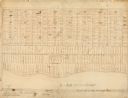
| Description: | This map, which was likely drawn in the mid-19th century, shows land ownership on the Stockbridge Reservation on the shore of Lake Winnebago in what is now... |

| Date: | 1977 |
|---|---|
| Description: | This 1977 map identifies the locations of 46 cemeteries in Calumet County, Wisconsin. Cemeteries are indexed by town. Also included are a civil town map, a... |

| Date: | 1837 |
|---|---|
| Description: | This manuscript map, copied in 1837 from a map in the Green Bay Land Office, Navarino, shows sections, the Shebowegan Trail, sandstone ledges, rivers, stre... |
| Date: | 1863 |
|---|---|
| Description: | This plat map of Brillion is ink and pencil on paper. The front of the map shows a plat of the town, roads, and Spring Creek, and includes a significant ha... |
| Date: | 1923 |
|---|---|
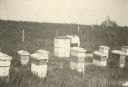
| Description: | Wisconsin beekeeper Albert Peglow posed standing outdoors among beehives in apiary. |
| Date: | 1836 |
|---|---|
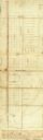
| Description: | This plat map shows the proposed Town of Whitesboro, a paper city (a city planned but never built), located on the Manitowoc River in Calumet County. Certi... |

| Date: | 1900 |
|---|---|
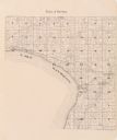
| Description: | This map shows landownership circa 1848 in the old Stockbridge Indian reservation on Lake Winnebago in Calumet County. It is oriented with north to the lef... |

| Date: | 1836 |
|---|---|
| Description: | This negative photostat map shows the "oak tree, place of beginning" on the division line between Stockbridge and Brothertown Indians, and Governor Porter'... |
| Date: | 1982 |
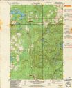
|---|---|
| Description: | This standard U.S.G.S. topographic map was annotated by civil engineer and railroad historian James P. Kaysen to show the location of existing and defunct ... |
| Date: | 1939 |
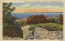
|---|---|
| Description: | Caption reads: "High Cliff overlooking East Shore of Lake Winnebago, Wis." Elevated view of Lake Winnebago from High Cliff State Park. A stone outcropping ... |
If you didn't find the material you searched for, our Library Reference Staff can help.
Call our reference desk at 608-264-6535 or email us at: