 Filter: Categories of Wisconsin Historical Images
Filter: Subject of Land
Filter: County of Clark
Filter: Categories of Wisconsin Historical Images
Filter: Subject of Land
Filter: County of Clark

| Date: | 1880 |
|---|---|
| Description: | Bird's-eye map of Neillsville, with inset. |

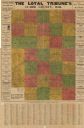
| Date: | 1910 |
|---|---|
| Description: | "There never was but one Crop of Land. There never will be another." Shows towns, boundaries, roads, schoolhouses, sawmills, cheese factories, and creameri... |
| Date: | |
|---|---|
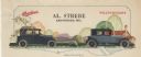
| Description: | Letterhead of Al. Strebe, dealer of Overland and Willys-Knight automobiles in Abbotsford, Wisconsin, with side views of women driving and riding in two aut... |
| Date: | 1924 |
|---|---|
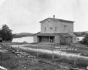
| Description: | The Humbird Roller Mill surrounded by rural landscape. A man leads on a porch beam as he poses for the picture. |
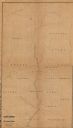
| Date: | 1873 |
|---|---|
| Description: | This 1873 map shows Clark County, Wisconsin, as well as the portion of Taylor County that was then part of Clark. The township and range grid, sections, ra... |

| Date: | 1880 |
|---|---|
| Description: | This 1880 map of Clark County, Wisconsin, shows the township and range grid, towns, sections, cities and villages, railroads, roads, rivers and lakes, dams... |

| Date: | 1914 |
|---|---|
| Description: | This early-20th century map of Clark County, Wisconsin, shows the township and range grid, sections, cities and villages, wagon roads, railroads, settlers,... |
| Date: | 1914 |
|---|---|
| Description: | This early-20th century map of Clark County, Wisconsin, shows the township and range grid, towns, sections, cities and villages, property owners and acreag... |

| Date: | 1936 |
|---|---|
| Description: | This 1936 map of Clark County, Wisconsin, shows the township and range grid, sections, cities and town, and lakes and streams in the county. It lacks the k... |

| Date: | 1933 |
|---|---|
| Description: | Blue line copy on paper with manuscript additions in color. Shows boundaries of zoned areas, Wisconsin historical lands in zoned areas, county lands outsid... |

| Date: | |
|---|---|
| Description: | View across field from board sidewalk towards a school near a hill, with an exposed bluff in the background. Identified as the Humbird School in Clark Coun... |
| Date: | 1905 |
|---|---|
| Description: | This blueprint map shows land parcels and roads. The map includes manuscript annotations in what appears to be red pencil. |
| Date: | |
|---|---|
| Description: | View toward a group o people gathered at a vacant lot. There are dwellings in the distance. Caption reads: "Lot Sale on Sub-Division, Granton, Wis." |

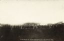
| Date: | |
|---|---|
| Description: | Elevated view of the Village of Humbird. Caption reads: "BirdeEye, Humbird, Wis." |
If you didn't find the material you searched for, our Library Reference Staff can help.
Call our reference desk at 608-264-6535 or email us at: