 Filter: Categories of Wisconsin Historical Images
Filter: Subject of Land
Filter: County of Forest
Filter: Categories of Wisconsin Historical Images
Filter: Subject of Land
Filter: County of Forest
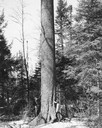
| Date: | 1945 |
|---|---|
| Description: | Two men stand at the base of the White Pine tree reported in 1945 to be the largest in the world at 16.8' in circumference and 140.42' in height. Larger sp... |
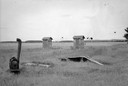
| Date: | 07 1941 |
|---|---|
| Description: | Two buildings, perhaps outhouses, and farm equipment in the vicinity of Crandon. |
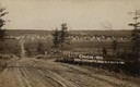
| Date: | 1908 |
|---|---|
| Description: | Caption reads: "Crandon—Wis. From Teachworth Hill". |
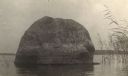
| Date: | 1905 |
|---|---|
| Description: | Rock near the principal village of the Chippewa Indian Reservation. |
| Date: | 1942 |
|---|---|
| Description: | Elevated view from hill towards the city of Laona on the far shoreline. A large smokestack is spewing smoke. Caption reads: "Laona, Wis." |
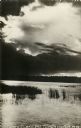
| Date: | 09 17 1961 |
|---|---|
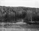
| Description: | View down hill towards backwater area of the Wolf River, near it's source, surrounded by thick woods. Crop marks indicated by photographer. |
| Date: | 1908 |
|---|---|
| Description: | Map shows swamps, windfalls, roads and railroads. Status of some land marked (O, S, X) but lacks explanation. |

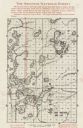
| Date: | 1967 |
|---|---|
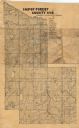
| Description: | This tourist brochure for Forest County, Wisconsin, includes a 1967 road map of the county which identifies points of interest, a location map, descriptive... |

| Date: | 1919 |
|---|---|
| Description: | "Map no. 2, Keith and Hiles Lumber Co., Crandon, Wisconsin, Block Map, Block One... Made December 20, 1919. Maker of original map, B. McGinley. Maker of ta... |

| Date: | 1905 |
|---|---|
| Description: | View looking up unpaved street and sidewalk of town, with dwellings on both sides, and a forested hill in the background. Caption reads: "Crandon, Wis." |
| Date: | 1910 |
|---|---|
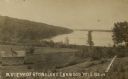
| Description: | View looking down hill towards Stone Lake, with wooded shoreline and a two-story log building in the foreground. Caption reads: "A View of Stone Lake, Cran... |
| Date: | 1905 |
|---|---|
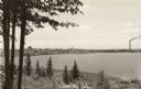
| Description: | Photographic postcard view of Lake Metonga, with marshy area in foreground. Caption reads: "On Famous Lake Metonga, Crandon, Wis." |
| Date: | 1935 |
|---|---|
| Description: | This map shows land for sale by the company in northwestern part of Nicolet National Forest. The map also shows shoreline acreages, railroads, roads, trail... |

| Date: | 1972 |
|---|---|
| Description: | A topographic map of the Blackwell quadrangle. |
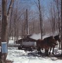
| Date: | 04 09 1971 |
|---|---|
| Description: | Two horses standing in the snow are hitched to a wagon holding a metal trough. Behind the horses smoke is rising up from the sugar house where maple sap is... |
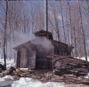
| Date: | 04 09 1971 |
|---|---|
| Description: | View uphill towards a sugar house, constructed of vertical logs, with a tall, metal chimney at the back. Smoke is coming out of the partially open double d... |

| Date: | 1950 |
|---|---|
| Description: | A man is harvesting potatoes using a John Deere tractor and a John Deere single row potato harvester. |

| Date: | 09 04 1909 |
|---|---|
| Description: | Text on front reads: "North Branch Street, Wabeno, Wis." Elevated view of a street and sidewalk with most of the storefronts and buildings on the far side.... |
If you didn't find the material you searched for, our Library Reference Staff can help.
Call our reference desk at 608-264-6535 or email us at:
