 Filter: Categories of Wisconsin Historical Images
Filter: Subject of Land
Filter: County of Green Lake
Filter: Categories of Wisconsin Historical Images
Filter: Subject of Land
Filter: County of Green Lake

| Date: | 1892 |
|---|---|
| Description: | Bird's-eye map of Princeton, with an inset of the Residence of F.T. Yahr. Fox River loops to left of center, with one bridge; thirty-six businesses, reside... |

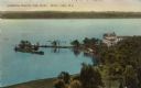
| Date: | 1910 |
|---|---|
| Description: | Exterior of the Sherwood Forest Hotel. The hotel burned August 11, 1923. Caption reads: "Sherwood Forest Hotel, Green Lake, Wis." |

| Date: | 11 05 1986 |
|---|---|
| Description: | Green Lake County Highway M meandering toward a red barn in the distance on a November day, an archtypal Wisconsin landscape. |

| Date: | 1900 |
|---|---|
| Description: | View across water toward the Princeton brewery on a bend in the Fox River. Caption reads: "A Bend in the Historic Fox at Princeton, Wis." |

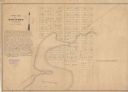
| Date: | 06 28 1958 |
|---|---|
| Description: | Official plat map drawn in ink and watercolor, T. 15 N, R. 11 E. |
| Date: | 09 10 1947 |
|---|---|
| Description: | Aerial view of the River View Cannery. |
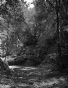
| Date: | |
|---|---|
| Description: | View of Mitchell's Glen, formerly owned by S.D. Mitchell. Rock formations are in a wooded area. |

| Date: | |
|---|---|
| Description: | Elevated view of a city park. In the background a hill is fenced off at the edge of the river where stone arches stand. |

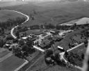
| Date: | |
|---|---|
| Description: | Elevated view of the countryside. Barns and dwellings are among fields and trees. |

| Date: | |
|---|---|
| Description: | Two men stand near a geological formation in Mitchell's Glen, formerly owned by S. D. Mitchell. |

| Date: | 1937 |
|---|---|
| Description: | A pictorial, hydrographic map shows sailing courses, historical and contemporary coastal attractions, roads, and the contour depths of Green Lake, Wisconsi... |

| Date: | 1913 |
|---|---|
| Description: | Ink and watercolor on tracing cloth. Shows parts of Green Lake, Princeton, and Brooklyn townships, Indian mound groups, Green Lake, and other significant b... |
| Date: | 1849 |
|---|---|
| Description: | The map reads: "Dartford is centrally located in Wisconsin, on the north side of Green Lake, and in full view of that beautiful sheet of Water. Its precise... |
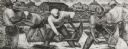
| Date: | |
|---|---|
| Description: | Cranberry harvesters at work. Mural painting in the U.S. Post Office at Berlin, Wis. |
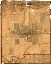
| Date: | 1875 |
|---|---|
| Description: | This map shows plat of the town, land ownership by name, wards, local streets, railroads, and part of Fox River. The map also includes a directory and adve... |
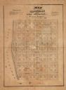
| Date: | |
|---|---|
| Description: | This plat map shows numbered blocks and lots, local streets, and part of Lake Apuckaway. The map also includes references for dimensions of lots, streets, ... |
| Date: | 1936 |
|---|---|
| Description: | Elevated view of Lawsonia Country Club and strip of land jutting out into Green Lake. Caption reads: "Lawsonia Country Club Point, Green Lake, Wis." |

| Date: | 1960 |
|---|---|
| Description: | Color elevated view of Inspiration Point on Green Lake. The swimming pool is in the foreground. At a dock are several moored rowboats and an excursion boat... |

| Date: | 1917 |
|---|---|
| Description: | View of sandstone cliffs on the shore of Green Lake. Caption reads: "Wave-worn Rocks at Sandstone, Green Lake, Wis." |

| Date: | 06 1952 |
|---|---|
| Description: | View across a prairie. Groves of trees, a herd of cattle, and a lake are in the distance. |
If you didn't find the material you searched for, our Library Reference Staff can help.
Call our reference desk at 608-264-6535 or email us at: