 Filter: Categories of Wisconsin Historical Images
Filter: Subject of Land
Filter: County of Langlade
Filter: Categories of Wisconsin Historical Images
Filter: Subject of Land
Filter: County of Langlade
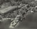
| Date: | 1954 |
|---|---|
| Description: | Aerial view of Kraftwood, the rural estate of the Kraft family of the Kraft Foods Co. of Wisconsin. The estate is situated on a peninsula jutting into Ente... |

| Date: | |
|---|---|
| Description: | Rural dirt road in the town of Antigo. Houses are in the distance. |
| Date: | |
|---|---|
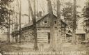
| Description: | Two-story log cabin and shed in a forest. The building was used by early settlers in Langlade County near Antigo. Caption reads: "The Home of an Early Land... |
| Date: | 1930 |
|---|---|
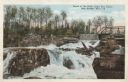
| Description: | View looking up toward the falls and bridge at the Dells of Eau Claire. Caption reads: "Scene at the Dells of Eau Claire, near Antigo, Wis." |

| Date: | 07 30 1895 |
|---|---|
| Description: | Two men stand in the five-foot tall pea field of Joseph Seipold three miles northeast of Antigo. Another man stands atop a horse-drawn wagon loaded with ha... |

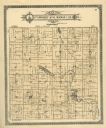
| Date: | 1908 |
|---|---|
| Description: | A map of Langlade County, Wisconsin that shows the townships and ranges, towns, cities and villages, wagon roads, churches, schools, lakes, rivers, railroa... |

| Date: | 1909 |
|---|---|
| Description: | A map of Langlade County, Wisconsin that shows townships and ranges, towns, cities and villages, wagon roads, churches, schools, sawmills, town halls, chee... |

| Date: | 1950 |
|---|---|
| Description: | Aerial view of town, showing all of Lake Metonga in the background. Caption reads: "Greetings from Crandon, Wisconsin." |

| Date: | 1947 |
|---|---|
| Description: | This map shows lakes, rivers, railroads, and the soil types of Langlade County. Legends of soil types, conventional signs, and stoniness and slope are incl... |
| Date: | 1913 |
|---|---|
| Description: | A plat map of the township of Norwood in Langlade County. |
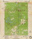
| Date: | 1973 |
|---|---|
| Description: | This standard U.S.G.S. topographic map was annotated by civil engineer and railroad historian James P. Kaysen to show the location of existing and defunct ... |
If you didn't find the material you searched for, our Library Reference Staff can help.
Call our reference desk at 608-264-6535 or email us at: