Filter: Categories of Wisconsin Historical Images
Filter: Subject of Land
Filter: County of Marinette
Filter: Categories of Wisconsin Historical Images
Filter: Subject of Land
Filter: County of Marinette
| Date: | 1871 |
|---|---|
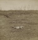
| Description: | Aftermath of Peshtigo fire on October 8, 1871. Devastated landscape with deer carcass in foreground. The Peshtigo fire razed the small town of approximatel... |
| Date: | 1945 |
|---|---|
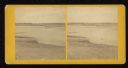
| Description: | Two fishermen on rocks alongside the Pike River. |

| Date: | 09 1871 |
|---|---|
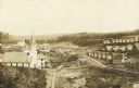
| Description: | Bird's-eye view of Peshtigo, before it was destroyed by fire on the night of October 8, 1871. |
| Date: | 1871 |
|---|---|
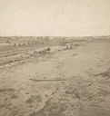
| Description: | Fire destruction near railroad tracks after Peshtigo fire. There are wheel carriages from destroyed boxcars on and near the tracks. |
| Date: | 1907 |
|---|---|
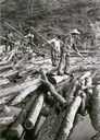
| Description: | Loggers breaking up a log jam in the Peshtigo River area. |

| Date: | 1881 |
|---|---|
| Description: | Bird's-eye map of Marinette, with insets. |
| Date: | 1910 |
|---|---|
| Description: | An elevated view of town. A church is on the left, houses are in rows on the right. Caption reads: "Made-For-Club-House — Niagara-Wis.—". |
| Date: | 1918 |
|---|---|
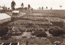
| Description: | Elevated view of two women working in a large vegetable garden. A long building, perhaps a barn, and a smaller building are on the left. In the background ... |
| Date: | |
|---|---|
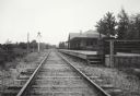
| Description: | View down railroad tracks which pass the Miscauno Island depot. A railroad signal is on the left, and the platform for the depot is on the right. |

| Date: | |
|---|---|
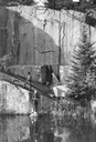
| Description: | Colorized view of a road along a river. Caption reads: "The River Road, Marinette, Wis." |

| Date: | 1896 |
|---|---|
| Description: | A map of Marinette County, Wisconsin that shows the sectioning of townships and other plots, towns, cities and villages, lakes and streams, railroads, and... |

| Date: | 1923 |
|---|---|
| Description: | A hand-colored map of Marinette County, Wisconsin that shows, townships, towns and plot sections, lakes and streams, cities and villages, and rail lines an... |

| Date: | 1900 |
|---|---|
| Description: | A map of Marinette County, Wisconsin shows the township and range system, sections, towns, cities and villages, streams and lakes, railroads, roads, school... |

| Date: | 1851 |
|---|---|
| Description: | This manuscript map of the southern portion of the Town of Porterfield, Marinette County, Wisconsin, shows sections and land ownership. The Menominee River... |

| Date: | 1887 |
|---|---|
| Description: | This manuscript map of the southern portion of the Town of Porterfield, Marinette County, Wisconsin, shows sections and land ownership. The Menominee River... |

| Date: | |
|---|---|
| Description: | This 19th century manuscript map shows the southeastern portion of the Town of Stephenson in Marinette County, Wisconsin. Sections, lakes, and streams are ... |

| Date: | |
|---|---|
| Description: | This 19th century manuscript map shows the sections and land ownership in the northern portion of the Town of Grover and the southern part of the Town of L... |
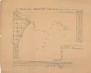
| Date: | 1856 |
|---|---|
| Description: | Shows sections and acreages. Covers portions of the area now occupied by Marinette and the Town of Peshtigo, Marinette County. "Rec’d Sept. 24 with Sur. Ge... |
If you didn't find the material you searched for, our Library Reference Staff can help.
Call our reference desk at 608-264-6535 or email us at: