Filter: Categories of Wisconsin Historical Images
Filter: Subject of Land
Filter: County of Monroe
Filter: Categories of Wisconsin Historical Images
Filter: Subject of Land
Filter: County of Monroe

| Date: | 05 31 1965 |
|---|---|
| Description: | Elevated view of Evangelical United Brethren church in the vicinity of Highway T. |
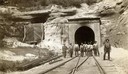
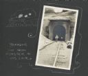
| Date: | |
|---|---|
| Description: | View down railroad tracks towards a group of construction workers posed near the east portal of the railroad tunnel near Tunnel City. |
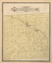
| Date: | 1897 |
|---|---|
| Description: | Plat Map of Glendale Township in Monroe County. |

| Date: | 06 29 1968 |
|---|---|
| Description: | View of rural Monroe County Highway P, looking east toward a house in the curve of the road. |

| Date: | 1928 |
|---|---|
| Description: | T. N19 R. 4W about section 19, McPeak farm. A 50 foot deep ravine is seen rapidly eating its way toward farm buildings. |
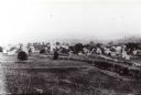
| Date: | 1880 |
|---|---|
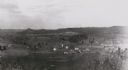
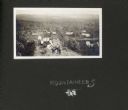
| Description: | Elevated view from hill towards farm fields and houses. Tree-covered hills are in the distance. |
| Date: | 1900 |
|---|---|
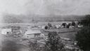
| Description: | Elevated view from hill towards farm fields and houses in Oil City. Tree-covered hills are in the distance. |
| Date: | 1911 |
|---|---|
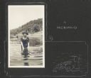
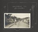
| Description: | Delia Drew King wades in Lake Flora Dell. There is a hill and shoreline in the background, and a group of people stands near a pier behind Delia. A hand-dr... |
| Date: | 1911 |
|---|---|
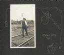
| Description: | Frank Drew (Frank King's father-in-law) walking railroad tracks. He was known as a prominent banker in the Tomah, Wisconsin community. A hand-drawn decorat... |
| Date: | 1911 |
|---|---|
| Description: | Frank Drew stands on the railroad tracks that run between Tunnel City and Lake Flora Dell. The tracks run into a tunnel in the background. A decorative bor... |
| Date: | 1911 |
|---|---|
| Description: | Frank Drew walks a set of railroad tracks near the entrance into a tunnel. The other end of the tunnel can be seen in the distance. A hand-drawn border fea... |
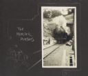
| Date: | 1911 |
|---|---|
| Description: | Front view of train emerging from a tunnel. A hand-drawn border features two male figures running away from the train and reads, "The monster pursues." |
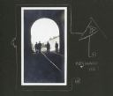
| Date: | 1911 |
|---|---|
| Description: | View from inside railroad tunnel of four men walking near the entrance on railroad tracks. A hand-drawn border features a pennant with the letter "A" on it... |
| Date: | 1911 |
|---|---|
| Description: | A group of men, women, and children pose on a bluff above Lake Flora Dell. In the background are several cottages surrounded by trees near the shoreline of... |
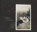
| Date: | 1911 |
|---|---|
| Description: | A group of individuals are gathered on a bluff. One man is pointing off to the left, and the rest of the group gazes in that direction. Features a hand-dra... |
| Date: | 1911 |
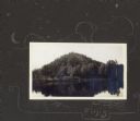
|---|---|
| Description: | View from lake of the bluff along shoreline of Lake Flora Dell. There is a hand-drawn decorative border, moon, stars and clouds, and the word "Finis." |
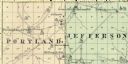
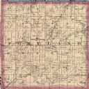
| Date: | 1878 |
|---|---|
| Description: | A map of Portland and Jefferson in Monroe County. |
If you didn't find the material you searched for, our Library Reference Staff can help.
Call our reference desk at 608-264-6535 or email us at: