Filter: Categories of Wisconsin Historical Images
Filter: Subject of Land
Filter: County of Pepin
Filter: Categories of Wisconsin Historical Images
Filter: Subject of Land
Filter: County of Pepin
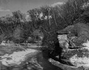
| Date: | 1950 |
|---|---|
| Description: | View looking up at the Methodist Episcopal church over tree covered formations on the banks of Arkansaw Creek. |
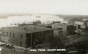
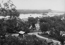
| Date: | 1910 |
|---|---|
| Description: | Elevated view of commercial buildings along the river from the vantage point of the Court House. Horse-drawn carriages and pedestrians are along the street... |
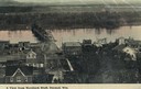
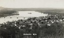
| Date: | 1900 |
|---|---|
| Description: | Elevated view of Durand. A street in the foreground leads to a bridge that crosses the river. Caption reads: "A View from Morsbach Bluff, Durand, Wis." |
| Date: | 1910 |
|---|---|
| Description: | Elevated view of Durand from a high vantage point, looking towards the river. A bridge spans the river, and in the foreground just below the hill is a chur... |
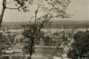
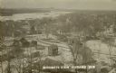
| Date: | 1910 |
|---|---|
| Description: | Elevated view from hill of Durand through trees, with houses in the foreground, and the river and hills in the background. Taken in the summer, with wash o... |
| Date: | |
|---|---|
| Description: | View from hill looking down at houses and buildings at an intersection. Beyond are commercial buildings, the river, and the far shoreline. Hills are in the... |
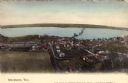
| Date: | 1905 |
|---|---|
| Description: | Elevated view of Stockholm and Lake Pepin. Caption reads: "Stockholm, Wis." |

| Date: | 1887 |
|---|---|
| Description: | This 1887 manuscript map by Amidon G. Miller covers portions of the towns of Nelson and Stockholm in Pepin County, Wisconsin, as well as a portion of the T... |

| Date: | 1913 |
|---|---|
| Description: | This 1913 map of Pepin County, Wisconsin, shows the township and range grid, towns, villages, rural routes, railroads, roads, schools, churches, cemeteries... |

| Date: | 1922 |
|---|---|
| Description: | This map of Pepin County, Wisconsin, from the first half of the 20th century shows the township and range grid, towns, villages, railroads, roads, schools,... |

| Date: | 1887 |
|---|---|
| Description: | This etching by Amidon G. Miller covers portions of the towns of Nelson and Stockholm in Pepin County, Wisconsin, as well as a portion of the Town of Maide... |
| Date: | 1910 |
|---|---|
| Description: | Elevated view of the town with snow on the ground. Houses are near an intersection in the foreground, and homes and commercial buildings are along the shor... |
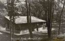
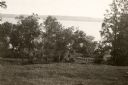
| Date: | 1910 |
|---|---|
| Description: | View looking downhill towards a small structure made of logs and with a large screened porch, set in a wooded area. A woman is standing on the walk near th... |

| Date: | 1930 |
|---|---|
| Description: | View looking up slope towards the brick high school building. Snow is on the ground. Caption reads: "High School, Durand, Wis." |
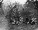
| Date: | 05 08 1927 |
|---|---|
| Description: | Actors (who are possibly Native American) posing outdoors near a lodge. They are participants in a reenactment of a ceremony in which Nicolas Perrot claime... |
| Date: | 05 08 1927 |
|---|---|
| Description: | A large group of actors posing together outdoors while in costume. They are participants in a reenactment of a ceremony in which Nicolas Perrot claimed the... |
| Date: | 05 08 1927 |
|---|---|
| Description: | A group of actors posing outdoors together in costume. They are participants in a reenactment of a ceremony in which Nicolas Perrot claimed the territory o... |
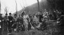
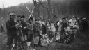
| Date: | 05 08 1927 |
|---|---|
| Description: | A crowd of people attending a reenactment of a ceremony in which Nicolas Perrot claimed the territory of the upper Mississippi River for France at Fort St.... |

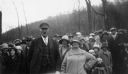
| Date: | 05 08 1927 |
|---|---|
| Description: | Two men are standing by a sign, near a fence, marking the former location of Fort Antoine. |
If you didn't find the material you searched for, our Library Reference Staff can help.
Call our reference desk at 608-264-6535 or email us at: