 Filter: Categories of Wisconsin Historical Images
Filter: Subject of Land
Filter: County of Washburn
Filter: Categories of Wisconsin Historical Images
Filter: Subject of Land
Filter: County of Washburn
| Date: | 09 1934 |
|---|---|
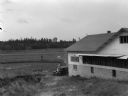
| Description: | View of a cranberry marsh and warehouse. In the foreground is a warehouse for the storage of harvested cranberries. |

| Date: | 09 1934 |
|---|---|
| Description: | Construction of a new drainage and water supply line for a cranberry marsh. Two men are standing on the right near the water. |

| Date: | 1914 |
|---|---|
| Description: | This early 20th century map shows the township and range system, sections, railroads, roads, lakes, wetlands, and streams in the western Sawyer County town... |

| Date: | 1896 |
|---|---|
| Description: | This 1896 map of Washburn County, Wisconsin, shows the township and range grid, sections, schools, wagon roads, cities and villages, settlers, railroads, a... |

| Date: | 1909 |
|---|---|
| Description: | This 1909 revision of Harmon's 1896 map of Washburn County, Wisconsin, shows the township and range grid, towns, sections, schools, wagon roads, cities and... |

| Date: | 1916 |
|---|---|
| Description: | This 1916 map of Washburn County, Wisconsin, shows the township and range grid, sections, towns, schools, wagon roads, cities and villages, post offices, s... |

| Date: | 1941 |
|---|---|
| Description: | This 1941 map covers Washburn County, Wisconsin, as well as western Sawyer, eastern Burnett, and northeastern Polk counties. It shows the locations of tour... |

| Date: | |
|---|---|
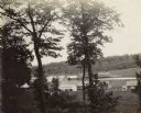
| Description: | Colorized photographic postcard view of a lawn with stone terraces and birch trees leading down to a lake on the left. There is a cabin in the background n... |
| Date: | 1900 |
|---|---|
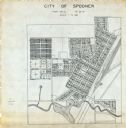
| Description: | This map is ink on tracing paper and shows the city of Spooner. The map shows numbered plats, labeled streets, and the Yellow River. |
| Date: | 1900 |
|---|---|
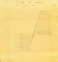
| Description: | This map of Minong shows township 42 north platted and area R12 west. The streets are labeled. |
| Date: | 1936 |
|---|---|
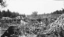
| Description: | Two groups of men are standing on a temporary wooden bridge over the Totogatic River. There is a large form in place on the left and a complete concrete wi... |
| Date: | |
|---|---|
| Description: | Exterior view down slope of several buildings. A sluice gate is partially visible, with several logs nearby. |
| Date: | |
|---|---|
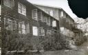
| Description: | External view along the side of the Kilkare Lodge, which is on a sloping hill. Many of the windows are open. |
| Date: | 1963 |
|---|---|
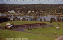
| Description: | Text on front reads: "Country House Motel." On reverse: "Country House Motel. Northwest's Finest - Highways 53 and 63. Room Phones - Color TV - Air-Conditi... |

| Date: | 1947 |
|---|---|
| Description: | Text on front reads: "Greetings - Spooner, Wis." A country road with a guard fence descends into a valley between tree-covered hills. The trees are showing... |

| Date: | 1947 |
|---|---|
| Description: | Text on front reads: "Greetings - Spooner, Wis." A country road descends into a valley between tree-covered hills. On the right are exposed rock faces at t... |
If you didn't find the material you searched for, our Library Reference Staff can help.
Call our reference desk at 608-264-6535 or email us at:
