Filter: Categories of Wisconsin Historical Images
Filter: Subject of Land
Filter: County of Waupaca
Filter: Categories of Wisconsin Historical Images
Filter: Subject of Land
Filter: County of Waupaca
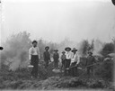
| Date: | 1910 |
|---|---|
| Description: | Group portrait of a fire fighting crew posing with buckets and shovels. They are battling the Big Falls Forest Fire. |
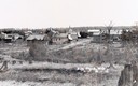
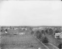
| Date: | 1900 |
|---|---|
| Description: | View from hill across field towards farmhouses, dwellings and churches along a road. In the foreground are stumps. Caption reads: "Big Falls, Wis." |
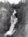
| Date: | 1940 |
|---|---|
| Description: | Big Manitou Falls with trees and observation area. |
| Date: | 1920 |
|---|---|
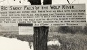
| Description: | Sign for the toll road at Big Smoky Falls on the Wolf River. The sign reads: "Big Smoky Falls of the Wolf River. Many years ago before 1925 there was no ro... |
| Date: | 1905 |
|---|---|
| Description: | A north-facing elevated view of Iola, with Main Street to the right. |

| Date: | 09 1982 |
|---|---|
| Description: | Nollenberg Road Bridge in the Town of Union. |

| Date: | 1910 |
|---|---|
| Description: | Aerial view of some of the 26 lakes known collectively as the Chain O' Lakes. Caption reads: "Aeroplane View of Chain O'Lakes, Waupaca, Wis." |

| Date: | 1896 |
|---|---|
| Description: | A map of the Chain-O-Lakes in Waupaca, including Indian trails. The path of the Waupaca Electric Railway from the Grand View Hotel to the Wisconsin Central... |

| Date: | 1898 |
|---|---|
| Description: | This 1896 map of the Chain-O-Lakes region of Waupaca County, Wisconsin, shows the lakes and streams, some topography, archaeological sites, roads, railroad... |

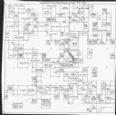
| Date: | 1898 |
|---|---|
| Description: | This 1898 map shows the contour depths of the Chain O' Lakes in Waupaca County, Wisconsin, and includes 15 cross sections of the lakes. Roads, parks, the W... |
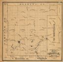
| Date: | 1870 |
|---|---|
| Description: | This 1870 map of Waupaca County, Wisconsin, shows the township and range grid, towns, cities and villages, and lakes and streams. |

| Date: | |
|---|---|
| Description: | Photographic postcard view down center of unpaved street in the central business district of a rural community. On the left is a general store, and on the ... |

| Date: | 1925 |
|---|---|
| Description: | Heavily rock-strewn hillside and rail fence. |
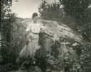
| Date: | 1900 |
|---|---|
| Description: | Full-length portrait of an unidentified woman posing near a rock at or near Big Falls. |
| Date: | |
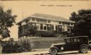
|---|---|
| Description: | View from street towards the Finney Library, with cars parked at an angle in front. The firm of H.T. Liebert of Milwaukee and Wausau was the architect. Cap... |

| Date: | 1974 |
|---|---|
| Description: | This map includes a diagram on the bottom left margin showing civil towns, a township numbering system, state highways, roads, lakes, and a legend on the r... |

| Date: | 1901 |
|---|---|
| Description: | This map shows landownership and acreages, townships and sections, and selected buildings. |
| Date: | 1971 |
|---|---|
| Description: | This map is a photocopy of a plat created in 1966 by Malcolm Rosholt which shows the community as it appeared in 1856. The map includes land owned by Norwe... |

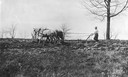
| Date: | 1922 |
|---|---|
| Description: | View across field towards a man standing and taking a drink from a stoneware jug. Beside him on the left is a team of two horses attached to a plow. Both h... |
If you didn't find the material you searched for, our Library Reference Staff can help.
Call our reference desk at 608-264-6535 or email us at: