 Filter: Categories of Wisconsin Historical Images
Filter: Subject of Land
Filter: Subject of water
Filter: Categories of Wisconsin Historical Images
Filter: Subject of Land
Filter: Subject of water
| Date: | |
|---|---|
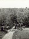
| Description: | Two people on a rustic bridge over Bad River at Copper Falls State Park. |

| Date: | 1890 |
|---|---|
| Description: | Bird's-eye map of Ashland, viewed from Lake Superior, with insets of Prentice Park and Fishery. Population 16,000. Increase in Ten Years, 11,000. |
| Date: | |
|---|---|
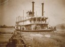
| Description: | View from raft towards the sternwheel rafter, Juniata, pushing a raft of lumber. The crew is posing on deck. The boat was later named the Red Win... |

| Date: | 1868 |
|---|---|
| Description: | The sidewheel packet, Keokuk, loaded with passengers beside a barge at a landing. The landing is filled with people and horse-drawn vehicles. The si... |
| Date: | 09 19 1892 |
|---|---|
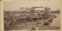
| Description: | Captain Alexander McDougall's whaleback passenger steamer "Christopher Columbus" under construction in the shipyard of the American Steel Barge Company in ... |
| Date: | |
|---|---|
| Description: | The sidewheel passenger and freight, "Milwaukee," at Dewey Hill, Grand Haven, Michigan, at the Detroit, Grand Haven and Milwaukee Railway depot. |

| Date: | 07 04 1931 |
|---|---|
| Description: | Inside of Saturday dinner menu for the "North American." Includes drawings of Niagara Falls, New York, Old Fort Mackinac Island, Michigan, Michigan Bouleva... |

| Date: | 1872 |
|---|---|
| Description: | The sidewheel packet, Red Wing, in the Mississippi River near Queen's Bluff below Trempealeau, Wisconsin. |
| Date: | 1906 |
|---|---|
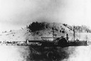
| Description: | Side view of the sidewheel packet, Quincy, sinking in 1906. Only her two upper decks are above water. Trempealeau Mountain is in the background. Lat... |

| Date: | 1831 |
|---|---|
| Description: | Drawing of Fort Winnebago (near present-day Portage) that illustrated "Wau-Bun," Juliette Kinzie's memoir of her experiences on the early Wisconsin fronti... |

| Date: | 1861 |
|---|---|
| Description: | Drawn the first year of the Civil War, this colored 1861 map of Dane County shows its towns, cities and lakes. It includes insets of the wards of Madison a... |
| Date: | |
|---|---|
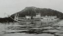
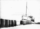
| Description: | The screw ferry, "Wisconsin," docked at Washington Island. Twenty-one metal drums line the edge of the dock in the foreground. Original is in scrapbook on ... |
| Date: | 1832 |
|---|---|
| Description: | Steamboat navigating through sunken trees on the Missouri River. |
| Date: | 1832 |
|---|---|
| Description: | Engraving of Indians on horseback along river with Indian grave on hill in background. |

| Date: | 1832 |
|---|---|
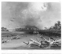
| Description: | Black and white engraving showing landscape with Fort Pierre and Indian tipis along the Missouri River. |
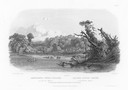
| Date: | 1832 |
|---|---|
| Description: | Punka Indians encamped on the banks of the Missouri River and canoeing in river. |
| Date: | 1832 |
|---|---|
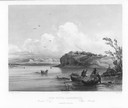
| Description: | Mih-Tutta-Hangkusch, a Mandan village with boats on the river in foreground. |

| Date: | 1832 |
|---|---|
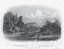
| Description: | Junction of the Yellowstone River and the Missouri River. |
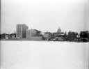
| Date: | 12 18 1955 |
|---|---|
| Description: | Downtown Madison lakeshore taken from Lake Monona in line with South Pinckney Street. Includes St. Raphael's steeple, 1 West Wilson Street state office bui... |
If you didn't find the material you searched for, our Library Reference Staff can help.
Call our reference desk at 608-264-6535 or email us at:
