Filter: Categories of Wisconsin Historical Images
Filter: Subject of Land
Filter: Subject of water-power
Filter: Categories of Wisconsin Historical Images
Filter: Subject of Land
Filter: Subject of water-power

| Date: | |
|---|---|
| Description: | Panoramic group portrait of workers, who are building the Penisular Power Company, located on the Brule River. |
| Date: | 1905 |
|---|---|
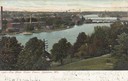
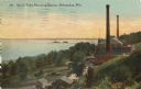
| Description: | View from hill looking down towards the Fox river. Caption reads: "Fox River Water Power, Appleton, Wis." |
| Date: | 1910 |
|---|---|
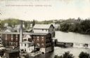
| Description: | Elevated view of the White Wagon Works and Rock Mills. Caption reads: "White Wagon Works and Rock Mills, Sheboygan Falls, Wis." |
| Date: | 1905 |
|---|---|
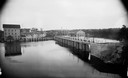
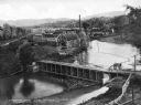
| Description: | View upriver towards a dam, and a power house on the right. |
| Date: | 1910 |
|---|---|
| Description: | Elevated view from hill toward the building which has two large smokestacks. The Lake Michigan shoreline is on the left. In front is a landscaped area with... |
| Date: | 1913 |
|---|---|
| Description: | Looking across water and through the locks to a shoreline with a large hill in the background. A building is on the left, a wall and pilings are in the wat... |
| Date: | |
|---|---|
| Description: | Elevated view of the mill, dam, and railroad tracks, and forests surrounding the area. The lumber mill itself, with main building complex and smokestack is... |

| Date: | 1915 |
|---|---|
| Description: | This 1915 map of Lincoln County, Wisconsin, shows the township and range grid, towns, cities and villages, lakes and streams, residences, churches, school ... |

| Date: | 1892 |
|---|---|
| Description: | This map shows the dams and locks of the Fox River between Neenah, in Winnebago County, Wisconsin, and Kaukauna, in Outagamie County. The cities and villag... |
| Date: | 1922 |
|---|---|
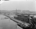
| Description: | Elevated view of the power plant and dam on the Wisconsin River. Two workers are walking near the center. On the opposite shoreline are fields and tree-cov... |
| Date: | 1908 |
|---|---|
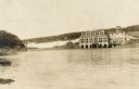
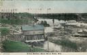
| Description: | Colorized photographic postcard of an elevated view of the power station next to the river. A bridge is in the background. Caption reads: "Power Station, B... |

| Date: | 1910 |
|---|---|
| Description: | Outdoor view looking down a hill towards a powerhouse on the river, with town buildings on a hill in the background. Identified as the second powerhouse th... |

| Date: | 1910 |
|---|---|
| Description: | Outdoor view looking down at a powerhouse on the river, with town buildings in the background. Identified as the second powerhouse that was replaced in 191... |

| Date: | 1910 |
|---|---|
| Description: | Outdoor view looking down at a powerhouse, with town buildings in the background and men fishing along the shoreline. Identified as the third powerhouse bu... |

| Date: | 1905 |
|---|---|
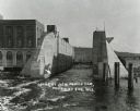
| Description: | View across water towards a powerhouse among very high water on the Black River. Identified as the second power house with high water in 1905. |
| Date: | |
|---|---|
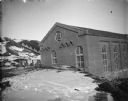
| Description: | Outdoor view across snow-covered ground towards a large brick building surrounded. There is a hill in the background. Location identified as the powerhouse... |

| Date: | |
|---|---|
| Description: | Outdoor view of the construction of a large building on top of a dam. Location identified as the construction of the powerhouse on the canal in Hatfield. |

| Date: | 1891 |
|---|---|
| Description: | This blueprint manuscript map shows land owned by Kaukauna Water Power Co., Green Bay & Mississippi Canal Co., A.W. Patten, N.M. Edwards, and M.J. Meade. P... |
| Date: | |
|---|---|
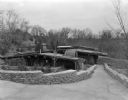
| Description: | The Mill House is another component of the compound at House on the Rock. |
If you didn't find the material you searched for, our Library Reference Staff can help.
Call our reference desk at 608-264-6535 or email us at: