 Filter: Categories of Wisconsin Historical Images
Filter: Subject of Land companies
Filter: Categories of Wisconsin Historical Images
Filter: Subject of Land companies

| Date: | 1912 |
|---|---|
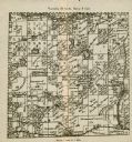
| Description: | Marinette County, Township 37 N., Range 20 E. |

| Date: | 1912 |
|---|---|
| Description: | Marinette County, Fract. Township 36 N., Ranges 21 and 22 E. |

| Date: | 1912 |
|---|---|
| Description: | Marinette County, Fract. Township 37 N., Ranges 21 and 22 E. |

| Date: | 1912 |
|---|---|
| Description: | This map shows land for sale by the Rusk Farm Company. Caption reads, "Look carefully at the map. Notice the thickly settled country on all sides of our la... |

| Date: | 1910 |
|---|---|
| Description: | This map of shows railway lines in red, with railroad land grant in Taylor, Price, and Ashland Counties shaded red, on top of the cities, counties, highway... |

| Date: | 1790 |
|---|---|
| Description: | An ink and hand-colored map, showing the land and landowners of the Susquehanna company purchase in Pennsylvania. Rivers are shown and occasionally labeled... |

| Date: | 1902 |
|---|---|
| Description: | A plat map of Lincoln County showing Township 34 North, Range 8 East. |
| Date: | 1902 |
|---|---|
| Description: | A plat map of a portion of Lincoln County, showing Township 35 North, Range 8 East. |

| Date: | |
|---|---|
| Description: | A photocopy of the T.34N, R.8E portion of a map of Lincoln County. |

| Date: | 1972 |
|---|---|
| Description: | A topographic map of the Blackwell quadrangle. |
| Date: | |
|---|---|
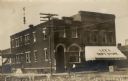
| Description: | View of a central intersection and city block with the State Bank on the corner, and Lee's Department Store (Ben C. Lee & Co.) next door on the right. A si... |
| Date: | 1890 |
|---|---|
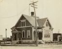
| Description: | View across street towards a two-story building, with a sidewalk, low fence and a telephone or power pole in front. There is a widow's walk and a chimney o... |

| Date: | 05 23 1935 |
|---|---|
| Description: | One of two images under the headline: "Lining Up to Draw for Location of Farms in Alaska." Original caption reads: "A serious business — these members of t... |

| Date: | 1901 |
|---|---|
| Description: | A plat map of Marathon county, 28 township, north range, 7 east. |

| Date: | 1901 |
|---|---|
| Description: | A plat map of Marathon county, township 28, north range, 8 east. |

| Date: | 05 23 1935 |
|---|---|
| Description: | One of two images under the headline: "Lining Up to Draw for Location of Farms in Alaska." Original caption reads: "A serious business — these members of t... |
| Date: | 05 23 1935 |
|---|---|
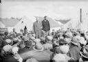
| Description: | View over heads of crowd towards two men standing above the the crowd. There are tents behind them, and mountains in the distance. Caption could be: "Same ... |

| Date: | 1935 |
|---|---|
| Description: | Mrs. Josephine Lemmon. Original caption reads: "Ron Sheely (left) Stewart Campbell (right) don't immediately identify woman in between. Don't remember what... |

| Date: | 1935 |
|---|---|
| Description: | Caption reads: "Martin McCormick, East [Tarvas], Mich., draws no. 1 in draw for position for final land lottery." |

| Date: | 1935 |
|---|---|
| Description: | Original caption reads: "Newsreel men re-enact the colony land drawing (or lottery)." |
If you didn't find the material you searched for, our Library Reference Staff can help.
Call our reference desk at 608-264-6535 or email us at: