 Filter: Categories of Wisconsin Historical Images
Filter: Subject of Land companies
Filter: Year of 1900-1999
Filter: Categories of Wisconsin Historical Images
Filter: Subject of Land companies
Filter: Year of 1900-1999
| Date: | 1925 |
|---|---|
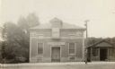
| Description: | The Knights of Pythias Castle Hall, formerly the Presbyterian Church, dedicated in 1844. The small building to the right of the church was built and occupi... |

| Date: | 1909 |
|---|---|
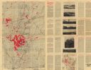
| Description: | Map of Sawyer County with an advertisement for land sales through Fuley & Quail of Hayward, Wisconsin. There is a small inset map of railroads accessible i... |

| Date: | 1900 |
|---|---|
| Description: | A map of Wisconsin, eastern Minnesota and Iowa, northern Iowa, and Michigan’s Upper Peninsula, showing railway lines, with those marked with heavy red line... |

| Date: | 1900 |
|---|---|
| Description: | A map of Wisconsin, eastern Minnesota and Iowa, and Michigan’s Upper Peninsula, showing the rail lines of the Wisconsin Central Railroad are shown in red, ... |

| Date: | 1911 |
|---|---|
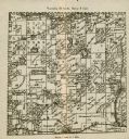
| Description: | This map of Polk County, Wisconsin, from the early 20th century shows the land for sale by the Baker Land and Title Co. of Saint Croix Falls. The township ... |

| Date: | 1914 |
|---|---|
| Description: | This map of Price County, Wisconsin, from the early 20th century shows land for sale by the Homemaker Land Company of Milwaukee. The township and range sys... |

| Date: | 1903 |
|---|---|
| Description: | This map of Richland County, Wisconsin, shows land ownership and acreages, the township and range grid, sections, cities, towns and post offices, roads, ra... |
| Date: | 1907 |
|---|---|
| Description: | "Lands colored in red owned and for sale by J.L. Gates Land Company, Milwaukee, Wis." Also shows wagon roads, railroads, schools, and settlers. On verso: M... |

| Date: | 1910 |
|---|---|
| Description: | Shows land for sale by Rusk Farm Co. in Rusk and Chippewa Counties, as well as farmhouses, roads, and railroads. |
| Date: | 1900 |
|---|---|
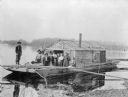
| Description: | Group of people on a wanigan, the "Dancing Annie," used by Chippewa Lumber and Supply Company near Eagle Rapids. A wanigan is a floating office and supply ... |

| Date: | 1912 |
|---|---|
| Description: | Marinette County, Township 36 N., Range 19 E. |

| Date: | 1912 |
|---|---|
| Description: | Marinette plat map, Township 37 N., Range 19 E. |

| Date: | 1912 |
|---|---|
| Description: | Marinette County, Township 36 N., Range 20 E. |

| Date: | 1912 |
|---|---|
| Description: | Marinette County, Township 37 N., Range 20 E. |

| Date: | 1912 |
|---|---|
| Description: | Marinette County, Fract. Township 36 N., Ranges 21 and 22 E. |

| Date: | 1912 |
|---|---|
| Description: | Marinette County, Fract. Township 37 N., Ranges 21 and 22 E. |

| Date: | 1912 |
|---|---|
| Description: | This map shows land for sale by the Rusk Farm Company. Caption reads, "Look carefully at the map. Notice the thickly settled country on all sides of our la... |

| Date: | 1910 |
|---|---|
| Description: | This map of shows railway lines in red, with railroad land grant in Taylor, Price, and Ashland Counties shaded red, on top of the cities, counties, highway... |

| Date: | 1902 |
|---|---|
| Description: | A plat map of Lincoln County showing Township 34 North, Range 8 East. |
| Date: | 1902 |
|---|---|
| Description: | A plat map of a portion of Lincoln County, showing Township 35 North, Range 8 East. |
If you didn't find the material you searched for, our Library Reference Staff can help.
Call our reference desk at 608-264-6535 or email us at: