 Filter: Categories of Wisconsin Historical Images
Filter: Subject of Land use, Urban
Filter: Type of Map or Atlas
Filter: Subject of transportation
Filter: Categories of Wisconsin Historical Images
Filter: Subject of Land use, Urban
Filter: Type of Map or Atlas
Filter: Subject of transportation

| Date: | 1892 |
|---|---|
| Description: | Bird's-eye view of Chicago, with ships in the Lake Michigan harbor. |

| Date: | 1892 |
|---|---|
| Description: | Bird's-eye view of the Columbian Exposition pavilions from the vantage point of Lake Michigan. Included is an inset of the Union Passenger Station (now Uni... |

| Date: | 07 01 1836 |
|---|---|
| Description: | Original plat map of the town of Madison on the four lakes. |
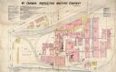
| Date: | 12 1898 |
|---|---|
| Description: | Fire insurance map showing the grounds and buildings of the McCormick Reaper Works, a factory operated by the McCormick Harvesting Machine Company. |

| Date: | 1885 |
|---|---|
| Description: | Fire insurance map of the McCormick Reaper Works, a factory of the McCormick Harvesting Machine Company. |

| Date: | 1792 |
|---|---|
| Description: | Map of Washington D.C. Labeled on the map are all the main streets, the site of the Capitol and the President's House. The map also shows the relationship ... |

| Date: | 1947 |
|---|---|
| Description: | This map of Wauwatosa shows 10 zoning class types of land including residential, manufacturing, and business. The map also shows government buildings, some... |

| Date: | 1939 |
|---|---|
| Description: | This is a zoning map of Wauwatosa with a key of districts including agricultural, resident, business, commercial, and industrial. The map features labeled ... |
| Date: | 1956 |
|---|---|
| Description: | This map of Rhinelander shows lots, 6 types of zoning in various colors; heavy industry, light industry, commercial, residence "A," residence "unrated," lo... |

| Date: | 1829 |
|---|---|
| Description: | This map of Munnomonee is ink and pencil on tracing cloth. The map shows a plat of the town, local streets, highways, land donations for public use, and pa... |

| Date: | 1923 |
|---|---|
| Description: | Map showing the parcel of land on the shore of Lake Monona acquired by the City of Madison for a park (today known as Olbrich Park). |

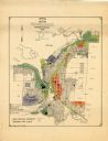
| Date: | 1902 |
|---|---|
| Description: | This map is a chart of Milwaukee Harbor that displays local streets, bridges, roads, railroads, public buildings, businesses, factories, dry docks, parks, ... |

| Date: | 1964 |
|---|---|
| Description: | This map shows various zoning sections and includes labeled streets, parks, and cemeteries. The upper left corner contains a legend of land use. |

| Date: | 06 02 1952 |
|---|---|
| Description: | This map shows five types of districts, as well as streets, railroads, water works buildings, and parks. The bottom left of the map has a key of district t... |
| Date: | 02 25 1965 |
|---|---|
| Description: | This blue line print map shows annexed land with ordinance numbers and dates. |

| Date: | 1961 |
|---|---|
| Description: | This map shows wards as well as proposed future streets, lot and block numbers, additions, and some landownership. The Sheboygan River is labeled. |

| Date: | 1905 |
|---|---|
| Description: | This blueprint map shows rivers, land parcels, and streets. It also highlights selected public and industrial buildings. |

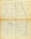
| Date: | 1910 |
|---|---|
| Description: | This map shows the Soo Line railroad and Arpin Hardwood Lumber Company lands in red. The top margin of the map reads: "Wisconsin, the safest state in the U... |

| Date: | 1904 |
|---|---|
| Description: | Map showing lots, additions, and wards within the city limits, as well as some landownership. The streets are labeled, as is Lake Winnebago, rivers, railro... |
If you didn't find the material you searched for, our Library Reference Staff can help.
Call our reference desk at 608-264-6535 or email us at:
